Is there a relationship between levels of stunting in Indian districts…
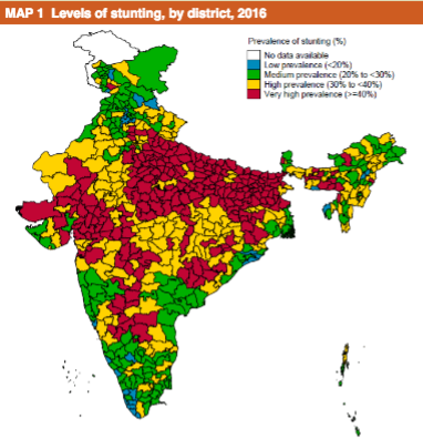
…and crop diversity in their farming systems (blue low, green high)?
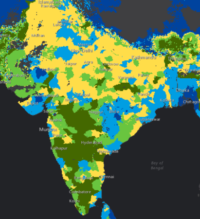
I have no idea. But I think we should be told.
Agrobiodiversity is crops, livestock, foodways, microbes, pollinators, wild relatives …
Is there a relationship between levels of stunting in Indian districts…
…and crop diversity in their farming systems (blue low, green high)?
I have no idea. But I think we should be told.
CGIAR launched its new portfolio yesterday, there was a Twitter chat thing, and I wrote a blog post about the Genebanks Platform. Not many people hurt.
How genetic improvement and crop intensification improve wellbeing
Glenn is ready to take up our challenge on crop distribution mapping:
I suppose that you could use “big data” & machine learning to find individual crop patterns in all that data. I think that some people are doing this kind of thing, but it’s private sector stuff. The global crop maps rely too heavily on data from surveys and censuses, and all the problems that come with those in terms of standardizing across countries.
Kinda. Sorta.
Susan Bragdon sounds frustrated:
It seems like the studies at least both confirm the dynamism in managing and developing landraces. One would expect some to go out of use and new landraces to emerge (good reason, amongst others, to have ex situ collections to have “snap shots” over time). I know I am saying nothing new to this audience, but in international circles — even some parts of the international world specifically addressing biological diversity (I can tell you about the Human Rights Council Resolution on Biological Diversity adopted in March as an example) — the idea that farmers are more than preserving a static pool of genetic resources is not well-understood. And don’t get me going on understanding the links to health, employment, peace…
What brought this on now, Susan? And if you want a platform for discussing those links, we do take guest posts.
I ran across a bunch of nice crop maps on the internet 1, so I made a GIF for you (click on it to get it cycling).
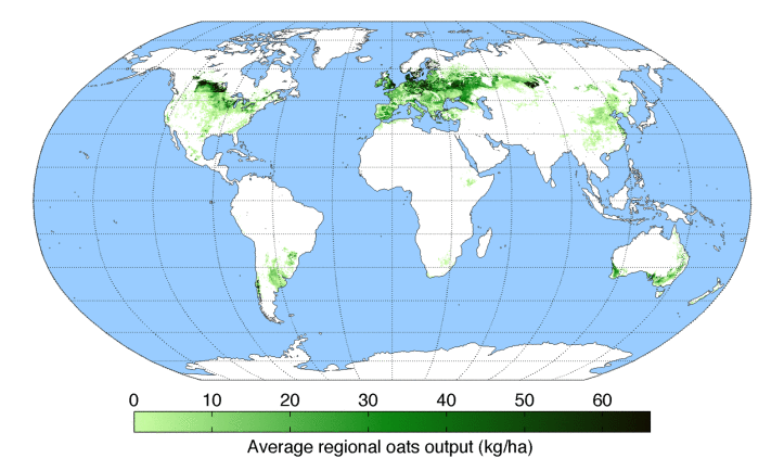
You’re welcome.
I’m reliably informed the source is Monfreda et al. (2008). You can download the data in multiple formats, but I don’t think I’ve ever seen the headline maps displayed all together as The Decolonial Atlas has done, albeit without attribution, which is naughty.
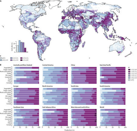
Anyway, people have obviously taken the trouble to download and play around with the data. For example, they have been ably mashed up by Bioversity to get a global crop diversity map.
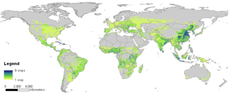
Which, in turn, it is instructive to compare with the one from the Lancet Planetary Health map we blogged about a few days ago.
But which dataset to use to do this kind of stuff? Monfreda’s is only one of many.
I see that we now, after a long wait, have WordClim 2, thanks to the work of our friend Robert Hijmans and his colleagues. 2 Is it too much to hope for that he’ll now turn his hand to producing the definitive crop distribution dataset? 3 Maybe something for the CGIAR’s Big Data Platform, just launched, to think about organizing, convening, and/or inspiring.