- NBPGR-PDS: A Precision Tool for Plant Germplasm Collecting. Fancy software can manage germplasm collecting info in the field.
- The role of genotypic and climatic variation at the range edge: A case study in winegrapes. Fancy software and analysis can predict how different grape varietals could expand in distribution under climate change.
- ClimMob: Software to support experimental citizen science in agriculture. Fancy software can help plan, manage and analyze large-scale, farmer-led germplasm evaluation trails.
- Herbarium specimen label transcription reimagined with large language models: Capabilities, productivity, and risks. Fancy software can transcribe herbarium labels.
- OliVaR: Improving olive variety recognition using deep neural networks. Fancy software can recognize olives.
- Reconstructing historic and modern potato late blight outbreaks using text analytics. Fancy software can track a pest epidemic.
- Evaluating responses by ChatGPT to farmers’ questions on irrigated lowland rice cultivation in Nigeria. Fancy software can be better than extension workers.
- Simulating pollen flow and field sampling constraints helps revise seed sampling recommendations for conserving genetic diversity. Fancy software and analysis can suggest changes to seed sampling strategies to take into account limited pollen flow.
Brainfood: Archaeology edition
- Early human selection of crops’ wild progenitors explains the acquisitive physiology of modern cultivars. The high leaf nitrogen, photosynthesis, conductance and transpiration of crops was already there in their wild relatives, the first farmers just happened to domesticate greedy plants.
- The impact of farming on prehistoric culinary practices throughout Northern Europe. When the first farmers arrived in northern Europe armed with their greedy plants, they learned a lot about food from the local hunter-fisher-gatherers, and vice-versa, but without much interbreeding. Jeremy interviews one of the authors on his podcast.
- Early contact between late farming and pastoralist societies in southeastern Europe. There was extensive interbreeding between farmers and the local transitional foragers/herders before with the expansion of pastoralist groups into Europe from the Eurasian steppes around 3300 BC.
- Isotopes prove advanced, integral crop production, and stockbreeding strategies nourished Trypillia mega-populations. The earliest European mega-settlements, in Ukraine and Moldova, from around 4000 BCE, integrated greedy crops and generous domesticated livestock.
- Inference of Admixture Origins in Indigenous African Cattle. Following introduction from the Near East, domesticated cattle got admixed with a North African extinct aurochs before spreading throughout Africa.
- Flax for seed or fibre use? Flax capsules from ancient Egyptian sites (3rd millennium BC to second century AD) compared with modern flax genebank accessions. Fibre first.
- Revealing the secrets of a 2900-year-old clay brick, discovering a time capsule of ancient DNA. DNA from 34 plant groups were detected inside an old brick when it happened to break.
- Making wine in earthenware vessels: a comparative approach to Roman vinification. Comparison with modern counterparts shows that Roman clay jars for storing wine were integral to the process. No word on whether there was any ancient DNA in the clay.
- Breadfruit in the Pacific Islands, its domestication and origins of cultivars grown in East Polynesia and Micronesia. Spoiler alert: they came from Polynesian Outlier Islands.
Canaries in the genetic coal mine
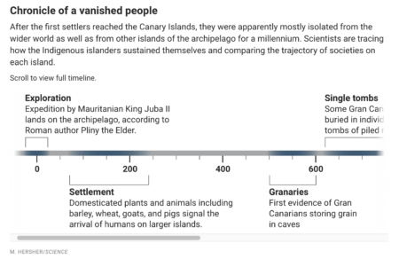
Specialism in science being what it is, it’s understandably unusual to see papers which combine combine analysis of genetic diversity in humans over time with that of crops, or indeed livestock. It’s less understandable why it should also be unusual in science journalism, and examples should be celebrated. So hats off to Warren Cornwall for his very readable synthesis in Science of the history of human and crop genetic diversity in the Canaries over the past two thousand years. Well worth a read.
References
Bean there, done that…
It’s that time of year again. Yes, the time to exchange bean seeds via the INCREASE project. Read all about it here, and get your beans ready for spring.
In memory of Rainer Schultze-Kraft
Reproduced from Tropical Grasslands-Forrajes Tropicales with permission.
It is with great sadness that we announce the death of Rainer Schultze-Kraft, a friend, colleague and mentor, whose experience and in depth understanding of tropical forages made him an outstanding forage scientist. Rainer dedicated his career to tropical forage research and development, working at CIAT and University of Hohenheim. He was an avid germplasm collector and added almost 10,000 forage accessions to global collections. He was one of the original team to work on the tropical forages interactive selection tool to support use of forages and one of the founders of the journal, acting as managing editor and guiding the journal through the early years. His passing leaves a big gap in the tropical forages community that will be hard to fill and he will be sorely missed by his friends and colleagues.
There is also an obituary on the website of the Alliance of Bioversity & CIAT.

