Charles Mann of 1491 and 1493 fame takes on the potato in the Smithsonian Magazine. So far as I can tell, all of the photographs are indeed of potatoes. It is kind of fun that one of the people who contributed to the amassing of the thousands of varieties in the germplasm collection maintained on behalf of the world by the International Potato Center has commented on CIP’s link to the article on Facebook.
Flooding out genetic resources in Thailand
More bad news from Thailand. After the worst floods in 50 years, the Chai Nat Research Centre has been under water for the past couple of months. That’s where a lot of the germplasm multiplication and regeneration work is done. In fact, it seems there were newly harvested seeds ready for storage when the floods came. Should any seeds make it to the national genebank at Pathum Thani near Bangkok, however, they would not be all that safe either. The area is under threat as the floodwaters makes their way south. That’s why the recommendation is for safety duplication of all accessions, preferably on another continent. And of course at Svalbard. Stay tuned for news as we get it. And very best of luck to all at the genebank.
Solving broomcorn millet
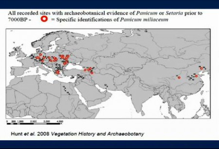
![]() Broomcorn millet is a bit of a puzzle. You start to get archaeobotanical evidence for cultivated Panicum miliaceum in both China and Europe at about the same time before 7000 BP.
Broomcorn millet is a bit of a puzzle. You start to get archaeobotanical evidence for cultivated Panicum miliaceum in both China and Europe at about the same time before 7000 BP.
Independent domestication or transmission along the fabled Silk Road (like wheat)? And if the latter, in which direction? You can hear the conundrum set out in more eloquent terms by the eminent archaeologist Prof. Colin Renfrew in this talk from last March, from which I’ve nicked the figure. You can just go to about 20 minutes in. But do yourself a favour and watch the whole thing.
Anyway, Prof. Renfrew mentions that genetic work is underway on Panicum which promises eventually to clarify the situation. And here it is. And, alas, interesting as it is, it doesn’t, not much. The paper in Molecular Ecology by Harriet Hunt and others looks at new microsatellite data on 98 landraces from across Eurasia obtained from genebanks in Russia, the US and Japan, and from new fieldwork in Inner Mongolia. 1
The researchers find evidence for two largely distinct genetic clusters, or genepools, one centered on China and one in Europe. And indeed of sub-clusters within each genepool. But they can’t use any of these data, even when combined with the archaeobotanical data, to distinguish between the separate domestication and Silk Road hypotheses. 2
The archaeobotanical and genetic data thus currently present a set of signals that are not wholly consistent with either a single or multiple domestication centres for P. miliaceum. Analyses to determine the direction of migration were uninformative for our data set.
Bummer. Ah, but there is hope: the wild relative!
The genetic picture would be clarified by comparison of landrace genetic diversity with that of the wild ancestor of broomcorn millet. Analysis of microsatellite diversity in P. miliaceum subsp. ruderale could determine whether this subspecies is indeed the wild ancestor of the domesticated form, in which case the former would be expected to maintain a more diverse genepool, or a derived feral type, whose genetic diversity is a subset of domesticated P. miliaceum.
So what’s stopping them?
We did not include any samples of P. miliaceum subsp. ruderale in the current study: Although morphotypes fitting the description of this taxon are reported as being widespread across the Eurasian steppe (Zohary & Hopf 2000), detailed information or samples are not easy to find. For example, P. miliaceum subsp. ruderale is not listed on the http://www.agroatlas.ru website, and no specimens are identified as belonging to this taxon in the extensive herbarium collection of P. miliaceum at the Royal Botanic Gardens, Kew. Appropriate field collections of weedy forms of P. miliaceum for genetic comparison with cultivated types are needed, but the necessary fieldwork across vast areas of Eurasia, to give a sample set from which reliable conclusions could be drawn, would require a major international collaborative project. Our demonstration of strong phylogeographic patterning in cultivated P. miliaceum makes fieldwork and sampling of P. miliaceum subsp. ruderale a high priority for further investigation.
Well, I know what they mean, but it’s not quite as bad as that. There are in fact 10 accessions labelled P. miliaceum subsp. ruderale in Genesys, originating from 8 countries and conserved in 4 genebanks in Europe and the USA. 3 Not a great haul, but a “major international collaborative project” has to start somewhere.
A new database helps you know your onions
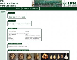
 A new paper in GRACE from our friends at IPK sent me scurrying to check out a new database. The snappily titled “The Garlic and Shallot Core Collection image database of IPK presenting two vegetatively maintained crops in the Federal ex situ genebank for agricultural and horticultural crops at Gatersleben, Germany,” by Christian Colmsee et al., describes the Garlic and Shallot Core Collection Database (GSCC). This database provides very nice photographs and morphological descriptor information on each accession in said core collection. You can get data on the whole collection, minus the photos, from IPK’s main database. And much the same minus the characterization data in Eurisco, but then you get all the other European Allium collections as well. 4 I haven’t found a way to search either the core collection or the full collection on the basis of specific characterization descriptors but who knows, maybe the photos are enough for most Allium germplasm users. Perhaps someone from IPK can drop us a comment on their future plans for these databases.
Nibbles: Chickens, Millet adoption, Specialty crops, World Food Day, Migrating forests, Vietnamese pheasants, Yews, High prices, Genebank tour, Climate change conference.
- Why did the Chinese chicken cross the road? To get a new date. For domestication, that is.
- The Indian Farmer is actually three, millet-wise.
- USDA wades into specialty crops. Wonder if one of them is baobab, and a factsheet is involved. Or “small scale grains” for that matter.
- “Life in the countryside is hard.” But fear not, FAO is on it.
- Forests are not migrating. Species are actually undergoing range contraction at both ends. Well that’s weird.
- The first pheasant extinction? Say it ain’t so.
- I like pictures of old trees. So sue me.
- Jess stops traffic.
- Tour a cocoa genebank. Could this catch on?
- International Conference on Climate Change and Food Security (ICCCFS). Not hot air.
