- Genetic Diversity and Population Structure of Tetraploid Wheats (Triticum turgidum L.) Estimated by SSR, DArT and Pedigree Data. Diversity in morphology and storage proteins in Italian durum varieties decreases after 1990, but not in molecular markers.
- Genetics driven interventions for ex situ conservation of red junglefowl (Gallus gallus murghi) populations in India. 9 birds from the most diverse population of 4 were selected to breed with all the others to rescue them from the perils of inbreeding.
- Geographic variation and local adaptation in Oryza rufipogon across its climatic range in China. Some variation correlated with geography, but plenty of plasticity too.
- Debate: Can Bioenergy Be Produced in a Sustainable Manner That Protects Biodiversity and Avoids the Risk of Invaders? It depends. But they’re not talking about agricultural biodiversity.
- Scenarios for future biodiversity loss due to multiple drivers reveal conflict between mitigating climate change and preserving biodiversity. Looks like growing biofuels to counter climate change might not be a great biodiversity conservation strategy. But we knew that from the above.
- Beyond ‘land sparing versus land sharing’: environmental heterogeneity, globalization and the balance between agricultural production and nature conservation. As the scale of analysis increases, you have to be more careful about addressing environmental heterogeneity. You mean like mosaics?
- Overview of long term experiments in Africa. Rotations are better than monoculture for soil fertility. Well, it’s good to have the data.
- Effects of boiling and frying on the bioaccessibility of β-carotene in yellow-fleshed cassava roots (Manihot esculenta Crantz cv. BRS Jari). Fry away. Finally some good news.
- Value chains of cherimoya (Annona cherimola Mill.) in a centre of diversity and its on-farm conservation implications. They can be bad.
Brainfood: Apples, Solanaceous breeding, AnGR valuation, Seed systems, IPR, Chestnut cryo, C4 exploitation, CC adaptation in China
- Crop-to-wild gene flow and spatial genetic structure in the closest wild relatives of the cultivated apple. Some evidence of genetic differentiation within species, but not as much as you’d think. Probably because of the significant gene flow in all directions.
- Biosynthesis of Antinutritional Alkaloids in Solanaceous Crops Is Mediated by Clustered Genes. Which means they can be fairly easily silenced.
- Assessing the total economic value of threatened livestock breeds in Italy: Implications for conservation policy. It’s worth it, but farmers will need incentives.
- Strengthening informal seed systems to enhance food security in Southeast Asia. Including through identifying potential commercial species and also the odd seed fair and bank.
- Can Certain Intellectual Property Rights both Protect and Promote Unique Traditional Products and Cultural Heritage from Developing Countries for Economic Benefit? The Case of Georgia. Maybe.
- In vitro conservation of chestnut (Castanea sativa) by slow growth. Ok, now what?
- Getting the most out of natural variation in C4 photosynthesis. Through sequencing of a couple of key species and lots of RNA profiling.
- Coping with climate-induced water stresses through time and space in the mountains of Southwest China. Including by changing crops, changing crop varieties and changing cropping patterns. But other ways as well.
Brainfood: Crop genomics, Phenotyping, Smallholders and markets, Yacon diversity, Indian rice HYVs, Sustainable landscapes, Climate models, Food prices
- Genomics reveals new landscapes for crop improvement. Which are dominated by the looming presence of Mount Phenotyping.
- Where Have All the Crop Phenotypes Gone? Someone mention phenotyping?
- Smallholder agricultural commercialization for income growth and poverty alleviation in southern Africa: A review. On balance, it’s a good thing.
- Genetic diversity of yacon (Smallanthus sonchifolius (Poepp. & Endl.) H. Robinson) and its wild relatives as revealed by ISSR markers. Low diversity among the cultivated stuff, which is quite distinct from the wilds. All due to clonal propagation. No concrete recommendations apart from conserving all you can find. Pity.
- Molecular Genetic Diversity of Major Indian Rice Cultivars over Decadal Periods. Genetic diversity among high yielding varieties released in India went up between 1970 and 2010.
- Ten principles for a landscape approach to reconciling agriculture, conservation, and other competing land uses. Adapt, involve, multitask. And more, much more, from Mongbay.
- Uncertainty, ignorance and ambiguity in crop modelling for African agricultural adaptation. Be open about assumptions, communicate with and involve diverse stakeholders in appropriate ways, accept feedback from policy-makers. Could be talking about GMOs. Or the above.
- The effect of rising food prices on food consumption: systematic review with meta-regression. Worse for poorer countries, and worse for poorer households in all countries.
Wild sorghum and aridity
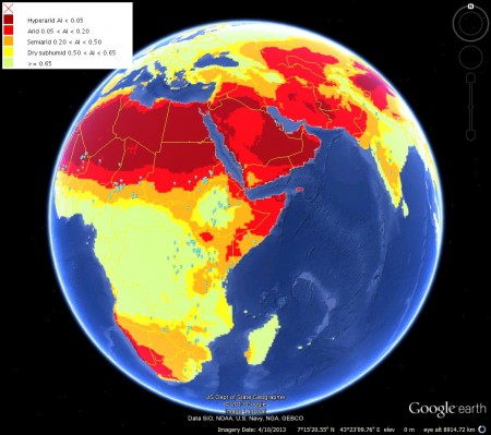
I’m not entirely sure why, but I get the occasional alert from something called the FAO GeoNetwork when a new dataset comes online. This morning it was global aridity. It’s not really very detailed or anything, but when something like that is available in a format that Google Earth can handle, I can very rarely resist the temptation of clicking on the link. So, in case you’re interested, this map shows the distribution of African wild Sorghum accessions in Genesys (that’s the little blue dots, which you’ll be able to see better if you click on the image — sorry about that) superimposed on that aridity thing.
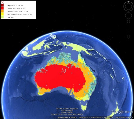
This suggests to me that if you want really drought-tolerant wild Sorghum germplasm, the Sahel is where to look, rather than southern Africa or South Asia. But what about Australia, I hear you ask? Well, Genesys doesn’t have any wild sorghum from Australia, but GBIF does.
Here we’re looking at herbarium specimens, remember, rather than genebank accessions, but it does seem that Australia may be a slightly better bet for aridity-adapted wild sorghums than Africa. But for hyper-arid adaptation, it’s the Sahara for you.
Is this automated Musa phylogeny any good?
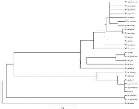
PhyloGenerator is “an open-source, stand-alone Python program, that makes use of pre-existing sequence data and taxonomic information to largely automate the estimation of phylogenies.” Sounds intriguing, no? I found out about it via this Twitter exchange with Rich Grenyer:
@rich_ @Phalaropus Sure, of course!
— AgroBioDiverse (@AgroBioDiverse) July 11, 2013
He very kindly shared his automatically generated Musa phylogeny, which is reproduced below. I’m afraid you’ll have to click on the image to read the species names.
So now I’m reaching out to all you banana taxonomists out there. Does this make any sense?


