- Translating High-Throughput Phenotyping into Genetic Gain. More to it than cool drones. Although those are not to be sneezed at.
- A guide to sequence your favorite plant genomes. Someone may already have what you need.
- Towards the Development of Perennial Barley for Cold Temperate Climates—Evaluation of Wild Barley Relatives as Genetic Resources. H. bulbosum is the best bet. So far.
- Communicating plant genetic resources for food and agriculture to the public — A study of grant-receivers with demonstration-projects in the Danish Rural Development Programme. It can be done.
- Farmers’ participatory selection of new rice varieties to boost production under temperate agro-ecosystems. It can be done.
- Assessing the Impacts of Agrobiodiversity Maintenance on Food Security Among Farming Households in Sri Lanka’s Dry Zone. Help the poor.
- Contribution of Traditional Farming to Ecosystem Services Provision: Case Studies from Slovakia. Traditional systems more diverse and balanced in provision of ecosystem services than intensive modern systems. The problem is that pesky production service. Yeah, but about that…
- Bright spots in agricultural landscapes: Identifying areas exceeding expectations for multifunctionality and biodiversity. Small is beautiful.
- Why should we save the wild relatives of domesticated animals? Because we can.
- Tracking trends in the extinction risk of wild relatives of domesticated species to assess progress against global biodiversity targets. And because we should.
- Single nucleotide polymorphism (SNP) diversity of cassava genotypes in relation to cassava brown streak disease in Mozambique. Some Mozambican landraces are very similar to resistant Tanzanian landraces.
- Generic names and mislabeling conceal high species diversity in global fisheries markets. DNA barcoding reveals that 300 “snapper” samples are in fact 67 species from disparate fisheries. Use Latin names, folks!
Brainfood: Italian hotspots, Spanish apples, ICRISAT proso, Scattered trees, Underutilized Malaysian fruit, Saudi chickens, AnGR, Double dates, European threatened plants, Pepper origins, Intensification outcomes, Breeding & diversity, Cold storage, African rice
- A methodological approach to identify agro-biodiversity hotspots for priority in situ conservation of plant genetic resources. Interestingly, the centre of Italy comes out on top.
- Genetic diversity and core collection of Malus × domestica in northwestern Spain, Portugal and the Canary Islands by SSRs. There is material in common between Galicia and the Canary Islands.
- Diversity and trait-specific sources for productivity and nutritional traits in the global proso millet (Panicum miliaceum L.) germplasm collection. Out of 200, 26 were high in at least 2 nutrients.
- The importance of scattered trees for biodiversity conservation: A global meta‐analysis. It’s pretty high.
- Origin and diversity of an underutilized fruit tree crop, cempedak (Artocarpus integer, Moraceae). The germplasm collections are not too bad, at least for the cultivated form.
- Genetic diversity of Saudi native chicken breeds segregating for naked neck and frizzle genes using microsatellite markers. The 6 breeds are diverse and show no inbreeding. Yet.
- Conservation of breeds and maintenance of biodiversity: justification and methodology for the conservation of Animal Genetic Resources. Ah, so that’s why they did the above.
- What are palm groves of Phoenix? Conservation of Phoenix palm groves in the European Union. Feral can still be useful.
- Date Palm Agrobiodiversity (Phoenix dactylifera L.) in Siwa Oasis, Egypt: Combining Ethnography, Morphometry, and Genetics. Some locally recognized and named types are in fact collections of genetically distinct clones that somehow go together anyway: call them “ethnovarieties” if you wish. But not feral.
- How to meet the 2020 GSPC target 8 in Europe: priority-setting for seed banking of native threatened plants. 62.7% of European threatened species are already in genebanks, but the others won’t collect themselves. No word on what to do about dates.
- Evolutionary history of the chili pepper Capsicum baccatum L. (Solanaceae): domestication in South America and natural diversification in the Seasonally Dry Tropical Forests. Probably originated in Bolivian Amazonia and inter-Andean valleys.
- Social-ecological outcomes of agricultural intensification. Win-wins are like hen’s teeth.
- Plant breeding and diversity: A troubled relationship? There may be another bottleneck coming.
- Rapid loss of seed viability in ex situ conserved wheat and barley at 4°C as compared to −20°C storage. 4°C is not cold enough for long-term conservation.
- Genetic control of seed shattering during African rice domestication. Multiple genes lead to a range of non-shattering phenotypes.
From little vegetable seeds…
Nunhems Netherlands b.v., currently a subsidiary company of Bayer (soon a subsidiary of BASF), specializing in vegetable varieties, has paid USD 119,083 to the International Treaty’s Benefit-sharing Fund, equaling 0.77% of seed sales of ten varieties of vegetables commercialized using germplasm made available by the Centre for Genetic Resources of the Netherlands (CGN) and the Leibniz Institute of Plant Genetics and Crop Plant Research (IPK) of Germany through the Multilateral System of Access and Benefit-sharing of the International Treaty. [links added]
A hugely important milestone for the Treaty and the whole plant genetic resources conservation community. Hopefully the first of many such announcements.
Keeping an eye in the sky on olives
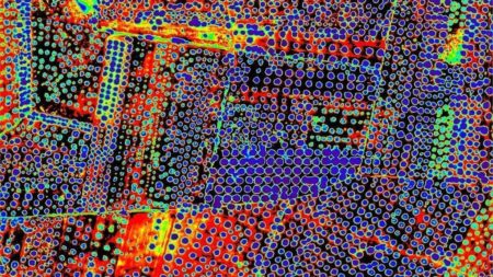
The latest on the very troubling Xylella outbreak in olives is that you can spot infestation from the air before it’s obvious on the ground.
The new research, published in the journal Nature Plants, demonstrates the first way to spot infected trees months before signs are visible to farmers. The scientists analysed more than 7,000 olive trees in 15 Italian groves over two years, both tree-by-tree on the ground and from the air.
Info on seed conservation experts online
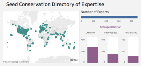
Botanic Gardens Conservation International has just put its Seed Conservation Directory of Expertise online. It “contains information on individuals, facilities and expertise related to seed conservation, focused on plant species of wild origin.”

If you’re not on it, and you think you should be, fill in the form.
