- Sensory sacrifices when we mass-produce mass produce. You need consumer-assisted selection.
- The palaeogenetics of cat dispersal in the ancient world. Two Middle-Eastern sub-populations of one sub-species contributed to domestication, at different times, and the result spread first with agriculture and then aboard ships. But we haven’t changed them in the same way we’ve changed dogs etc. You don’t say.
- U.S. ratification of Plant Treaty: benefit sharing ambiguity for plant genomics researchers does not change. But what about genomics data?
- Wading Into the Gene Pool: Progress and Constraints Using Wild Species. Introduction to the Special Section on CWR.
- Plant ecological solutions to global food security. Introduction to the Special Feature on Ecological Solutions to Global Food Security. The intersection with the above is probably here.
- A multiplex PCR for rapid identification of Brassica species in the triangle of U. Now there’s no excuse.
- Connecting Earth observation to high-throughput biodiversity data. I don’t see any reason why the same thinking couldn’t be applied to crop diversity.
- Linguistic diversity of natural UNESCO world heritage sites: bridging the gap between nature and culture. 80% of Natural WHSs intersect at least one indigenous language.
- Overcoming barriers to active interventions for genetic diversity. Embrace the hybrid by focusing on process, not form.
- Utilization and farmers’ knowledge on pigeonpea diversity in Benin, West Africa. For some reason, farmers don’t like coloured seeds.
Arise, Sir Daniel
From the Facebook page of the Crop Trust:
Our friends at CIAT inform us that yesterday Daniel Debouck received the Order of Leopold for his 40 years of service to the scientific community. Named in honour of King Leopold I, and awarded by Royal order, this is the highest order of Belgium. We congratulate Daniel, who’s one of the tireless scientists at the front lines of agro-biodiversity conservation. As head of the Genetic Resources Unit at CIAT, he’s made sure the world’s largest bean, cassava and forages collections are safe and available for plant breeders, researcher and farmers to use.
Since its inception, CIAT’s genebank has distributed more than half a million samples from 141 countries to requesters in more than 160 countries. Find out more here.
Well done, Daniel! Great to see the work of another genetic resources scientist being recognized.
Read more about Daniel’s work on a recent CIAT blog post, “On the trail of ancient treasure in Peru.”
Seed saving in Tanzania in the spotlight
An article in Mint Press News suggests that a new law in Tanzania will not only give foreign investors “faster and easier access to agricultural land in the African nation, as well as strong protections for ‘intellectual property rights,’ e.g., seed patenting,” but also forbid seed saving and exchange.
In addition, seeds that are not patented – i.e., all seeds traditionally used by Tanzanian farmers – are now forbidden from being sold or even given to friends or family, threatening the centuries-old tradition of seed exchanges that have kept costs down for farmers. Michael Farrelly of the Tanzania Organic Agriculture Movement (TOAM) told Mondiaal Nieuws that “Eighty percent of the seeds are being shared and sold in an informal system between neighbors, friends and family. The new law criminalizes the practice in Tanzania.”
All in return for aid, allegedly. The Seed Treaty is brought in as a last line of defence:
However, the new laws themselves are likely illegal under international law, as Article 9 of the International Treaty on Plant Genetic Resources for Food and Agriculture (ITPGRFA), also known as the “Seed Treaty,” states that no law should “limit any rights that farmers have to save, use, exchange and sell farm-saved seed/propagating material.” But affected Tanzanian farmers will likely be unable to make a viable court case against the new legislation due to their limited economic resources.
It’s worth quoting Article 9 in full:
Article 9 – Farmers’ Rights
9.1 The Contracting Parties recognize the enormous contribution that the local and indigenous communities and farmers of all regions of the world, particularly those in the centres of origin and crop diversity, have made and will continue to make for the conservation and development of plant genetic resources which constitute the basis of food and agriculture production throughout the world.
9.2 The Contracting Parties agree that the responsibility for realizing Farmers’ Rights, as they relate to plant genetic resources for food and agriculture, rests with national governments. In accordance with their needs and priorities, each Contracting Party should, as appropriate, and subject to its national legislation, take measures to protect and promote Farmers’ Rights, including:
a) protection of traditional knowledge relevant to plant genetic resources for food and agriculture;
b) the right to equitably participate in sharing benefits arising from the utilization of plant genetic resources for food and agriculture; and
c) the right to participate in making decisions, at the national level, on matters related to the conservation and sustainable use of plant genetic resources for food and agriculture.
9.3 Nothing in this Article shall be interpreted to limit any rights that farmers have to save, use, exchange and sell farm-saved seed/propagating material, subject to national law and as appropriate.
So that’s not quite the same as what the Mint Press News piece said, as I read it. It’s not that no law should “limit any rights that farmers have to save, use, exchange and sell farm-saved seed/propagating material.” It’s that nothing in Article 9 should be interpreted as so doing. The Treaty recognizes the pivotal importance of Farmers’ Rights, including to seed saving and exchange, but leaves it to national government to figure out how to realize them.
FAO rolls out agricultural apps
FAO, along with several partners, is involved in the implementation of ICT initiatives in Africa. The majority of family farmers in developing countries live rural areas and in most cases don’t have access to technology and digital agricultural services. Through the use of ICTs, farmers have more access to information on markets, weather and nutrition. The Digital Services project is part of FAO’s Digital Strategy and is aimed at people in the field, local governments, community leaders and extension workers.
These are the apps involved:
- Cure and Feed your Livestock
- e-Nutrifood
- Weather and Crop Calendar
- AgriMarketplace
Maybe it’s not too much to hope for a genetic erosion early warning system after all? We could test it in Haiti.
Maize for Haiti; but from Haiti?
Good news for hard-pressed Haitian farmers.
The International Maize and Wheat Improvement Center (CIMMYT) has grown 150 tons of renewed, improved maize seed that will be sent to Haitian farmers to help jump-start the country’s seed sector, improve local food security and decrease malnutrition. This will be the largest seed shipment to any country in CIMMYT’s history.
But are there any maize landraces left in Haiti that this much-needed effort will displace? If so, it will be important to collect them. Genesys lists 78 landraces from the country, most at the genebank of CIMMYT itself, collected thus:
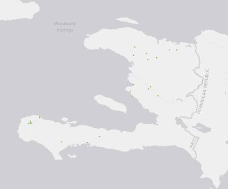
Maybe enough. Maybe not…