Do you know of projects genotyping or phenotyping crop germplasm on a massive scale? Well, because the folks at DivSeek are collating that kind of info for a “landscape study.” Leave comments here and I’ll get it to them.
How long can rice seeds stay alive for?
Of course, the answer is what it always is: it depends. But you can hear (and see) all the details thanks to Mike Jackson, who has made available on his blog both an audio file and the PowerPoint slides pertaining to a recent seminar on the subject by Fiona Hay of IRRI’s genebank. Thanks, Mike. And thank, Fiona.
And if the subject really grabs you, there’s a post-doc position going in France.
Brainfood: Wild rice database, E Asian wheat diversity, Microbial terroir, Sesame breeding, Agrobiodiversity fairs, AnGR conservation, Rye diversity
- OryzaGenome: Genome Diversity Database of Wild Oryza Species. Well, only 2 species thus far, but it’s a start.
- Evaluation of East Asian landrace wheat revealed by high molecular weight glutenin and maturity period. The Chinese accessions are different to the Japanese-Korean, and 3 of the former have both good gluten composition and early maturity, making them attractive to Korean breeders.
- Sequence-based Analysis of the Vitis vinifera L. cv Cabernet Sauvignon Grape Must Mycobiome in Three South African Vineyards Employing Distinct Agronomic Systems. Even microbes contribute to terroir.
- Genetic Diversity, Population Structure, and Association Mapping of 10 Agronomic Traits in Sesame. Some markers will be really useful in breeding.
- The fairs of agrobiodiversity in the context of participatory plant breeding — Local Agricultural Innovation Program in Cuba. Meaning and impact. Diversity will find a way.
- Biobanking genetic resources: Challenges and implementation at the USDA National Animal Germplasm Program. Everything that’s not cattle and swine is a problem.
- Geography and end use drive the diversification of worldwide winter rye populations. There may have been multiple domestications, and improvement has not led to decrease in diversity.
Featured: GRIN-Global
Marty wants to point out that someone else beat USDA to GRIN-Global adoption:
Footnote #2 – our friends at the Czech Republic Crop Research Institute also have GRIN-Global fully up and running.
True, and very much due to the unstinting efforts of the late, much missed Dr Iva Faberova.
Climate change, food systems and nutrition: what’s to be done?
The Global Panel on Agriculture, Food Systems and Nutrition has come out with a Statement on Climate Change, Food Systems and Nutrition, in the run-up to a side event at COP21 in Paris. Nothing particularly surprising there, but I just wanted to highlight two things. First, I was impressed by how the problem was set out:
Climate change is expected to push down global farm output by 2% per decade between now and 2050. Demand for food is expected to rise substantially during that same period.
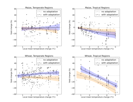
Yes, those fancy IPCC synthesis diagrams (see below) are cool and everything, but there’s a lot to be said for the directness and starkness of those two sentences. Sometimes a few well-chosen words are better than a picture.

Then there are the policy recommendations:
1. Include diet quality goals with adaptation targets proposed for climate action.
2. Diversify agricultural investments, factoring in the local realities of ecological sustainability and comparative advantage.
3. Support greater food system efficiency so that outputs per unit of water, energy, land, and other inputs are optimised and the footprint of agriculture and non-farm activities are better managed to meet both food demand and higher-quality diets.
4. Integrate measures to improve climate change resilience and the nutritional value of crop and livestock products along the value chain, from production to marketing.
5. Protect the diet quality of the poor in the face of supply shocks and growing food demand through social protection, for example.
6. Promote the generation and use of rigorous evidence on appropriate investments along food value-chains, which are resilient to climate change and also deliver positive dietary outcomes and support improved nutrition.
And it’s striking how agricultural biodiversity in one way or another could be argued to underpin all of these.