“…these maps do us no good unless they become public knowledge and indigenous rights are recognized by all who have ambitions to grab our lands.”
That’s Abdon Nababan of the Indonesia’s Indigenous Peoples’ Alliance, on LandMark, “a new tool launched today by a broad partnership including the World Resources Institute (WRI), …the first online, interactive platform for mapping lands managed by native communities.” And I would add that such maps will remain of limited usefulness even when they’re in the public domain if they cannot be manipulated, combined and shared much more easily than is currently the case.
Here’s Exhibit A. It is possible, with a little (well, a lot) of techie fiddling (no, not by me), to superimpose an image of what’s in Genesys (the green dots) with an image of what’s in LandMark (the brown polygons showing officially community-managed lands).
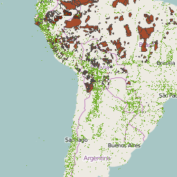
But it’s not pretty, I think you’ll agree: it gets even uglier when you zoom in, which is why I’ve decided not to let you do it. And you can’t do much with it anyway, apart from eyeball it. Plus it may well be against the terms of use of either or both Genesys and LandMark.
Well, we’ll see how LandMark develops, maybe a Google Earth export is in its future, in which case people like Abdon Nababan will be able to get the most out of it. And also the national plant genetic resources programme in Brazil, say, which may well be interested in supporting indigenous communities in protecting their crop diversity more than is perhaps occurring now. That would be a win-win. A triple win, in fact, if you add me.