- Triangulation supports agricultural spread of the Transeurasian languages. People speaking the precursor of Japonic, Koreanic, Tungusic, Mongolic and Turkic languages started out around the West Liao River and then spread with their Panicum millet farming, mixing with other populations and picking up rice and wheat along the way.
- Artificial selection in the expansion of rice cultivation. They managed to get to Hokkaido with that rice because of a couple of genes. Rice genes, that is.
- Pip shape echoes grapevine domestication history. If they had carried grapevines, we’d be able to say which varieties.
- Shaping the biology of citrus: I. Genomic determinants of evolution. They maybe had a role in citrus domestication, but a lot of the hard work was done by the prior adaptive radiation of the group. The citrus group, that is. Quick summary of both papers here if you can get access to it.
- Yak Domestication: A Review of Linguistic, Archaeological, and Genetic Evidence. They weren’t involved in yak domestication, though, I don’t think.
- The Evolutionary History of Wild, Domesticated, and Feral Brassica oleracea (Brassicaceae). Nor that of Brassica oleracea, whose closest wild relative turns out to be half a world away on Crete.
- Coffee: Genetic Diversity, Erosion, Conservation, and Utilization. Ok, stay with me here. Brassica oleracea is related to Brassica carinata, which originated in Ethiopia, which is also where arabica coffee comes from.
- Surveying Grassland Islands: the genetics and performance of Appalachian switchgrass (Panicum virgatum L.) collections. If you can find a close connection between coffee and switchgrass you get a prize. Ah no wait, there are 2 ploidy levels, just like in Coffea. Yeah, I know it’s tenuous.
- Agrobiodiversity-Oriented Food Systems between Public Policies and Private Action: A Socio-Ecological Model for Sustainable Territorial Development. These guys really know their onions. And think they can use their conservation as a spur to local development. In Italy, but who’s to say it couldn’t work in Ethiopia as well.
- Putting diverse farming households’ preferences and needs at the centre of seed system development. Imagine.
Agrobiodiversity manifestly important
The process leading up to the just-started 2nd International Agrobiodiversity Congress included coming up with the “Rome Manifesto: Using Agrobiodiversity to Transform Food Systems.” This highlights three “commitments to help tackle global challenges including climate change, malnutrition, biodiversity loss, and environmental degradation.”
- Consume diverse foods in diets that are nutritious, sustainable, affordable, acceptable, safe, and accessible to all.
- Produce food in diverse, resilient, and sustainable food systems.
- Conserve agrobiodiversity to give people the options they need to sustainably and inclusively transform food systems and improve lives, both now and in the future.
Yeah but how, you ask? You’ll have to attend the congress to find out, I guess, or at least follow on Twitter…
Brainfood: Chickpea genomes, DIIVA, Maize evolution, Malting barley, Wild gluten, Cucurbit review, Coconut genome double, USDA rice collection, CIAT bean collection, PGRFA data integration, USA cattle diversity, PGRFA history
- A chickpea genetic variation map based on the sequencing of 3,366 genomes. Where the good and the bad alleles are. Even The Economist is impressed.
- Crop Wild Relatives Crosses: Multi-Location Assessment in Durum Wheat, Barley, and Lentil. There are lots of good alleles in the wild relatives.
- The arches and spandrels of maize domestication, adaptation, and improvement. Some alleles are good by accident, and that’s ok.
- Malting Quality of ICARDA Elite Winter Barley (Hordeum vulgare L.) Germplasm Grown in Moroccan Middle Atlas. Here are some alleles for good beer.
- High molecular weight glutenin gene diversity in Aegilops tauschii demonstrates unique origin of superior wheat quality. And here are some alleles for good gluten. In a wild relative from unexpected place, as it turns out. More in the press release.
- Genetic resources of bottle gourd (Lagenaria siceraria (Molina) Standl.] and citron watermelon (Citrullus lanatus var. citroides (L.H. Bailey) Mansf. ex Greb.): implications for genetic improvement, product development and commercialization: a review. Not just good as rootstocks, and lots of alleles to play with.
- Coconut genome assembly enables evolutionary analysis of palms and highlights signaling pathways involved in salt tolerance. Looks like coconut might have lost a lot of good alleles at the end of the Pleistocene glaciations.
- High-quality reference genome sequences of two coconut cultivars provide insights into evolution of monocot chromosomes and differentiation of fiber content and plant height. The same gene controls height in coconuts as in maize and rice.
- Enhancing the searchability, breeding utility, and efficient management of germplasm accessions in the USDA−ARS rice collection. And now you can look for rice germplasm with the good height allele you want.
- History and impact of a bean (Phaseolus spp., Leguminosae, Phaseoleae) collection. Hopefully will be able to do the same for this bean collection soon.
- Integrating Genomic and Phenomic Approaches to Support Plant Genetic Resources Conservation and Use. The above, summarized.
- Gene Bank Collection Strategies Based Upon Geographic and Environmental Indicators for Beef Breeds in the United States of America. The above, plus environmental data, for cattle.
- History of Global Germplasm Conservation System. The above, writ large.
Keeping up with the Agrobiodiversity Congress
Just a quick reminder that the virtual 2nd International Agrobiodiversity Congress kicks off on Monday. It’s got all the requisite social media paraphernalia. I’ll try to tweet about it when I can. The hashtag is #EatGrowSave.

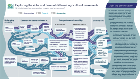
Confused about woke agricultural movements?
Not to worry, TABLE is here with a handy cheat sheet.
Now you can tell your agroecology from your regenerative agriculture from your organic agriculture.
I have two questions though. Why not also have “conventional” agriculture in there? And, is it really that important to know these differences?
