


Shea producers in Leo, Burkina Faso go Digital, a set by IICD on Flickr.
Nibbles: Environmental health index, Data visualization, Hungry World, Vegetables meeting, FFS, ICTs in ag, ILRI review, Devil’s claw, Cassava pests, Greek seed meet, Dolphins
- “…the world’s first environmental health index to be based on long term historical data” not actually as interesting as it sounds.
- Data porn. Aggregated. There oughta be a law… Speaking of infoporn, though, check out the third one here.
- AlertNet site on Solutions for a Hungry World pretty but broken. Media alerted, so by the time you read this they may have fixed it and you won’t get Haiti no matter what you click.
- Warwick meeting to look at vegetables and food security. You going? Will you tell us about it?
- Farmer field schools in El Salvador. Diversification seems to be on the curriculum. But diversity?
- And are they using — or being taught — ICTs?
- ILRI reprises a high-impact article. And why not. Nice idea, actually. I may steal it.
- Devil’s claw: weed or NUS? Both!
- Cassava not such a Rambo after all? Heading for a quagmire in SE Asia.
- Greek seed savers met a couple of weeks back. Where you there? Would you like to tell us about it?
- Speaking of seeds, would you like to help save the D. Landreth Seed Company?
- More social dolphins more likely to help humans fish. I wonder if the same for, say, ancient wolves.
Indian animal genetic resources institute sets its priorities
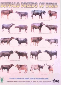 While looking for something else 1 I came across the news on the website of India’s National Bureau of Animal Genetic Resources (NBAGR) that the genome of the water buffalo has been sequenced. I also found out that you can buy attractive calendars featuring native breeds such as the one you see here. And that NBAGR has a catchy song. Alas, the Information System on Animal Genetic Resources of India does not seem to work.
Nibbles: Scuba rice, Climbing beans, Bees, Forests and food security, New avocados, Land grab, Homogenocene, Drought, Fibre, Organics, CBD, Bean breeding, Rice record
- The CGIAR Consortium finds a CGIAR success story. While the Guardian does another.
- Talk on honeybee diversity at UC Davis. Hopefully Robert will be available for comment. Meanwhile, across the Pond…
- Seeing the food security for the trees.
- Yeah I’m just not sure it’s such a good idea to name a new avocado variety Uzi, no matter how good it may be.
- Deconstructing the global land rush. And here’s the data… Jatropha everywhere.
- The deep roots of globalization. Move over jatropha.
- More on that paper on how to recognize a relatively drought-tolerant species.
- All tangled up in natural fibres.
- How to read organic agriculture debates. Just in case you actually want to read them.
- An Indian prepares for the Convention on Biological Diversity‘s meeting in Hyderabad in October. Not too early, is it?
- Bean breeders! Funding alert! You have nothing to lose but your diversity.
- India posts world record rice harvest — using System of Rice Intensification. Take that, doubters.
Brainfood: Alfalfa, Date palm, Apricot, Collecting, Reintroduction, Ribes, Payments
- Assessment of genetic diversity among alfalfa (Medicago sativa L.) genotypes by morphometry, seed storage proteins and RAPD analysis. Morphology fits with geography, the others don’t.
- Insights into the historical biogeography of the date palm (Phoenix dactylifera L.) using geometric morphometry of modern and ancient seeds. Analysis of seed outlines using fancy maths identifies centres of diversity and migration routes.
- Loss of genetic diversity as a signature of apricot domestication and diffusion into the Mediterranean Basin. Or you could use microsatellites. Result: an Irano-Caucasian centre of domestication and two migration routes, N and S of the Mediterranean.
- Big hitting collectors make massive and disproportionate contribution to the discovery of plant species. Therefore, fund a small number of expert collectors in the right places. Luigi stands ready.
- Success Rates for Reintroductions of Eight Perennial Plant Species after 15 Years. Are pretty pathetic. Makes you wonder if all that collecting is worth it.
- Conservation of endemic insular plants: the genus Ribes L. (Grossulariaceae) in Sardinia. Seems rather a fuss for 1 species and 1 subspecies, crop wild relatives or not.
- Indicator-based agri-environmental payments: A payment-by-result model for public goods with a Swedish application. Hang on a minute, why is crop diversity not there?