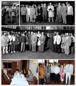
 Trevor Williams, one of the key early figures in the movement to conserve crop diversity, has passed away at 76. Mike Jackson has done a great job of summarizing Trevor’s pivotal contribution to the field over at his blog. Many have left touching tributes, including a number of people whose careers Trevor was instrumental in getting off the ground. I’m proud to be in that category. Mike is also working on obituaries for the Daily Telegraph, and for Genetic Resources and Crop Evolution, to both of which I’ll be sure to link in due course. The funeral will be held on Wednesday 22 April at 13:30, at St Chad’s Church, Handforth, Cheshire. Trevor’s sister Wendy has asked that a donation be made to the Millennium Seed Bank at Kew in lieu of sending flowers. Further details on Mike’s blog.
DOI see the future of genebank documentation?
Mike Jackson, indefatigable blogger and former manager of the IRRI genebank (among other things), is on a mission.
I’m on the editorial board of Genetic Resources and Crop Evolution. I have proposed to the Editor-in-Chief that any manuscript that does not include the germplasm accession numbers (or provenance of the germplasm used) should be automatically sent back to the authors for revision, and even rejected if this information cannot be provided, whatever the quality of the science! Listing the germplasm accession numbers should become a requirement for publication.
Draconian response? Pedantic even? I don’t think so, since it’s a fundamental germplasm management and use issue.
As regular readers will suspect, we’re totally behind Mike’s pedantically draconian suggestion here. We’ve said much the same thing ourselves on occasion. We’ve even taken it a step further and suggested globally unique identifiers for each genebank accession. Well, not entirely coincidentally, Genesys has just announced a major new feature along these lines:
Genesys database was upgraded to allow for enhanced handling of archived accession data. Accession records in Genesys are assigned a Universally Unique Identifier and are accessible with Persistent Uniform Resource Locators.
A step in the right direction? Over to you, genebank data geeks.
Vanuatu field collections survive cyclone
A smidgen of good news from the Pacific island country of Vanuatu, recently hit so cruelly by Cyclone Pam. This just in 1 from Roger Malapa, who’s in charge of the various field genebanks at the Vanuatu Agricultural Research and Technical Centre (VARTC) on the beautiful island of Santo, which was apparently less badly affected than others.
Minor damage to the banana collection but overall, everything is fine at VARTC and Santo. Yes there is enough material in the multiplication plots, mainly the root crops. I have just selected an early maturing variety on February: two-month harvest. We are harvesting our cassava now so cuttings can be prepared.
SPC’s Centre for Pacific Crops and Trees (CePaCT) does hold duplicates of some of these collections in vitro. But you can never have enough safety duplication in the Pacific.
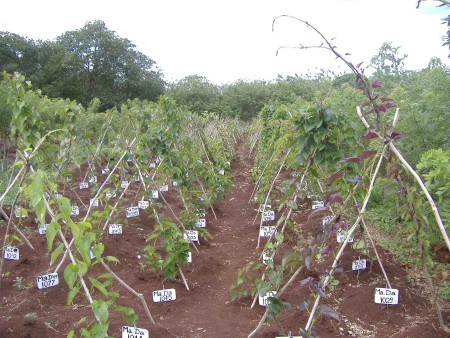
Here’s what a bit of the root and tuber crop collection at VARTC looked like a few years ago when I last visited.
A book worth waiting for

An old friend, Frederik van Oudenhoven, and his friend and colleague Jamila Haider, are deep in the proofs of what looks to be a wonderful book. With Our Own Hands “tells, for the first time, the cultural and agricultural history of the Afghan and Tajik Pamirs, one of the world’s least known and most isolated civilisations”. Should be a great read, with stunning photographs to accompany the local recipes, essays, stories and poetry. Better yet, generous donors are allowing 1800 copies to travel back to the Pamirs to be given to communities, schools, cooks and libraries.
If you’re interested, you should pre-order. Details here.
Brainfood: Resilience and diversity, Cold tolerant rice, Old baobabs, VIR, Local adaptation, Prunus phylogeny, Bactris mating, Land use change, Wheat landraces, Amazonian agrobiodiversity
- Does Plant Species Richness Guarantee the Resilience of Local Medical Systems? A Perspective from Utilitarian Redundancy. It depends on how knowledge is distributed.
- COLD1 Confers Chilling Tolerance in Rice. From a wild relative.
- Searching for the Oldest Baobab of Madagascar: Radiocarbon Investigation of Large Adansonia rubrostipa Trees. 1,600 years seems to be the record.
- Genetic resources of cultivated plants as the basis for Russia’s food and environmental security. VIR needs Roubles 425 million a year ($14.3 million).
- Using archaeogenomic and computational approaches to unravel the history of local adaptation in crops. Models say that adaptation to higher latitudes was rapid, simple (few genes) and unstable.
- Combining conservative and variable markers to infer the evolutionary history of Prunus subgen. Amygdalus s.l. under domestication. Almonds and peaches were domesticated on either side of the Central Asian Massif from different sections of the genus that had been there for 5 million years.
- Conservation implications of the mating system of the Pampa Hermosa landrace of peach palm analyzed with microsatellite markers. Bactris effective population size in genebanks is too small.
- Global effects of land use on local terrestrial biodiversity. Within-sample total terrestrial species diversity down by 13.6% globally. About the same for crop wild relatives?
- Exploiting genetic diversity from landraces in wheat breeding for adaptation to climate change. It would be a good idea.
- Household Agrobiodiversity Management on Amazonian Dark Earths, Oxisols, and Floodplain Soils on the Lower Madeira River, Brazil. Age of household head, size of household and area of land under cultivation predict amount of agricultural biodiversity managed.