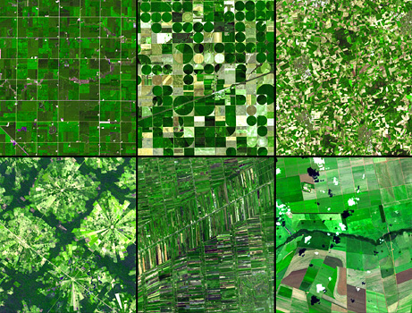
Like patchwork quilts, satellite views of farming patterns around the world form the above montage of images taken by the Terra satellite.
At top-left, a regular grid pattern suggests that agriculture was shaped by 19th-century surveying in Minnesota. Meanwhile, center-pivot irrigation in Kansas is responsible for the circles visible in the second image. A well in the middle of each field serves as a pivot point for wheeled, spraying watering machines.
In the top-right image of northwest Germany, small and disorganized fields can be traced back to the less-planned farming of the Middle Ages.
Curious pie-shaped fields in the lower-left image are the result of a planned settlement near Santa Cruz, Bolivia. At the center of each field is a village, while a buffer of rain forest separates each community.
In Thailand, at bottom-center, rice paddies just outside Bangkok form skinny slices. The purple fields are flooded, a normal part of rice’s life cycle.
At bottom-right, Brazil’s woodland-savanna cerrado contains massive farms, a by-product of the flat land’s inexpensive price.
Many thanks, NASA and National Geographic.
I always thought that those circular fields were interesting looking. But I have always wondered why they didn’t tessellate the circles like in a honeycomb? There would be a lot less extra space.