If you’ve been reading this blog for any length of time you’ll know I have a thing about agricultural atlases. Well, here’s another one. Mexico’s Instituto de Geografia has put its Atlas Nacional de Mexico online, and it includes maps of crop production such as these (dating back to 1989, though). However, these are just high definition scans rather than real digital maps, which makes them slow to load and difficult to use. But beautiful to look at.
SINGER cartogram
Following my earlier post about cartograms, here’s one for the germplasm collections catalogued in SINGER, by country of origin. Thanks to Dr Robert Hijmans of IRRI for the birthday present.

Cool cartograms
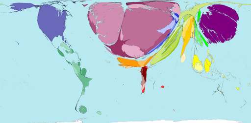
Cartograms are maps where the sizes of territories (countries, say) are proportional not to the surface area of their real-world counterparts, but rather to the value of some other attribute, like population or GDP or incidence of malaria. You can see lots of really wonderful examples on the Worldmapper website. That includes a few agricultural variables and some forestry stuff. Here’s an example of the former, net imports of vegetables by $ value.

As I said earlier in connection with Gapminder, wouldn’t it be great to be able to produce cartograms from FAOSTAT data? Or what about from the data in SINGER? Well actually that shouldn’t be all that difficult, the code for making your own cartograms is available, according to Worldmapper’s FAQ. Any volunteers?
Cartogram © Copyright 2006 SASI Group (University of Sheffield) and Mark Newman (University of Michigan), reproduced by permission. Worldmapper is at: www.worldmapper.org
Syrian agricultural stats
You may remember a post some time back on an atlas of agriculture in Bhutan. Now here’s an on-line database of governorate-level agricultural statistics for Syria. Maybe not as nice as an atlas, but still pretty useful for planning agricultural biodiversity conservation. Especially as there is time-series data going back to 1985, which could be used to identify areas of genetic erosion through the (admittedly imperfect) proxy of decreasing total acreage. But when will agricultural statisticians and census-takers start collecting data on numbers of varieties, at least of staple crops?
Accessing biodiversity in Brazil
Brazil has new procedures in place (called Sisbio) to issue licences to collect biodiversity for teaching and research, according to an article on SciDevNet. They are supposed to make the whole access system much easier to navigate. And faster: what used to take up to two years should now take 45 days at most. This bit struck me in particular:
Scientists will eventually be able to use Sisbio to access satellite images of potential research areas and gauge research activity in areas so they can better plan their research.