- Crop diversity trends captured by Indigenous and local knowledge: introduction to the symposium. A whole symposium on how Indigenous knowledge reveals widespread loss of traditional crops and landraces, and the increasing adoption of high-yielding varieties, driven by economic, political, climatic, and sociocultural forces.
- Landraces and climate change: global trends through the lens of political agroecology. Structural forces (markets, policies) and unequal power in seed systems drive the decline of traditional varieties and marginalize Indigenous and local knowledge about crop diversity; climate change not so much.
- Smallholders farmers defying global genetic erosion: documenting 60 years of peanut landrace conservation in a South American diversity center. Well, not everywhere. I wonder why…
- Farmers hold diverse and connected values towards crops. The global literature shows that farmers value crops not just for yield and profit, but for a wide range of interconnected economic, agronomic, ecological, social, and cultural reasons that vary across farming systems, and recognizing these diverse values can improve research and policy on agricultural sustainability and crop diversity. So that’s why.
- Towards a holistic framework: Exploring the relationship between seed security and food security dynamics among smallholder farmers in Chimanimani, Zimbabwe. The link between smallholder seed and food security is complex, non-linear, and shaped by socio-economic, environmental, and policy factors, showing that having secure access to seed does not automatically translate into food security and that context-specific, systemic approaches are needed to understand and strengthen both.
- The local crop varieties (farmers’ varieties) registration system in Nepal: Past, present and future. It may all be very complex, but legally recognizing and protecting farmer-developed landraces within a formal seed regime can empower farmers, conserve agrobiodiversity, and strengthen seed system resilience.
- Leveraging Earth Observation Technologies to Monitor Essential Genetic Diversity. Nah, we can do it from space.
Another chance for Bambara groundnut
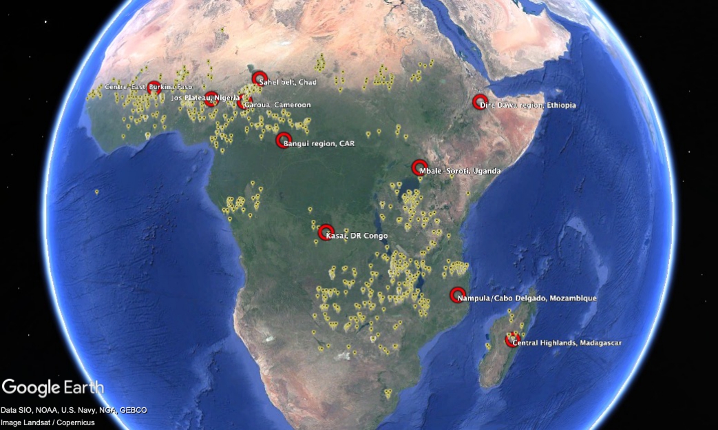
Yesterday’s Nibble on the annoyingly always-on-the-verge-of-breaking-through Bambara groundnut had me rummaging through the blog’s archives. Among dozens of references, I came across a post from almost 15 years ago that included some maps — of genebank accession localities and the distribution of the crop. On a whim, I downloaded the Genesys data and fed it into the maw of ChatGPT, asking it to identify gaps in the world’s ex situ holdings. For each of the top 10 priority collecting regions, I then asked for a best-bet locality for exploration. ChatGPT obliged with a KML file, which I then looked at in Google Earth, together with the accession localities.
This is the result.
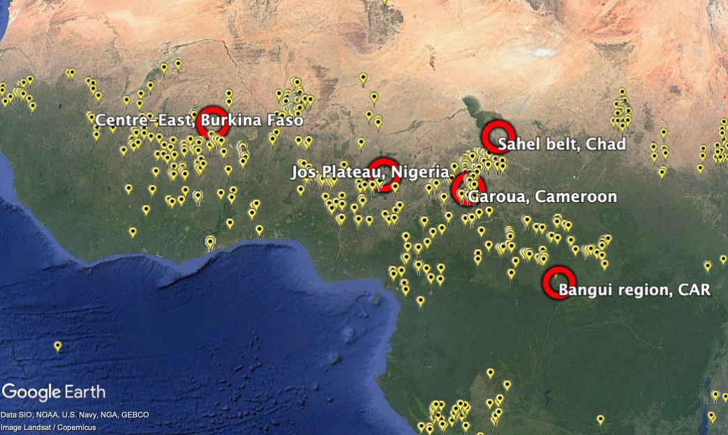
And here’s close-up on West Africa, because that’s where accessions are densest, and the suggested “gaps” a little more difficult to understand.
Asked for a justification, this is what the LLM came up with.
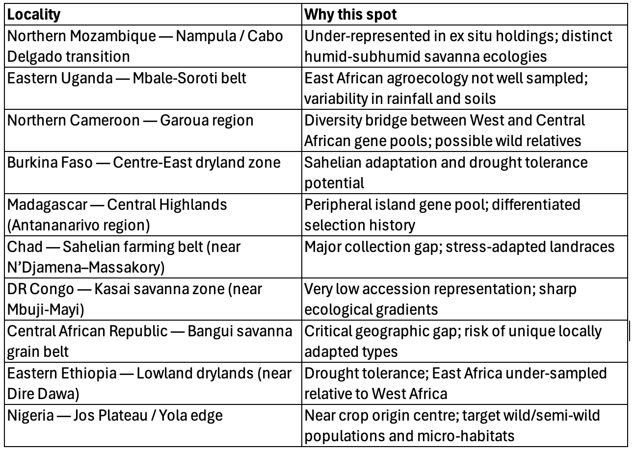
Does it make any sense? Well, it’s not exactly where I would have plumped for, just eyeballing the data. But it is not complete nonsense. Maybe it was the prompt? Any ideas what that should look like to get the best results?
Not that any of this is going to help Bambara groundnut much, I suspect.
Brainfood: Biodiversity intactness, Landuse change, Drought stress, Crop suitability, Yield variance, Phenotypic data
- Consistent global dataset on biodiversity intactness footprint of agricultural production from 2000 to 2020. Spatial dataset shows how global consumption drives ecological degradation.
- Rapid monitoring of global land change. Spatial dataset shows how in 2023 direct human action and fires caused land use conversion globally over an area the size of California.
- Remote monitoring of plant drought stress with the apparent heat capacity. Spatial dataset can provide early warning of drought. Early warning system for genetic erosion, anyone?
- CropSuite v1.0 – a comprehensive open-source crop suitability model considering climate variability for climate impact assessment. Spatial dataset shows where 48 crops will have the best yields.
- Climate change increases the interannual variance of summer crop yields globally through changes in temperature and water supply. Spatial dataset shows that climate change impacts not just yields but variation in yield from year to year for maize, soybean and sorghum.
- Reassessing data management in increasingly complex phenotypic datasets. Datasets need to be properly managed to be widely used.
Brainfood: Taxonomic identification, Niche mapping, Harvest tracking, Drones, Phenomics, Yield analysis
- Review of herbarium plant identification of crop wild relatives using convolutional neural network models. Cool tech helps you figure out which species is which. Now you can map them properly I guess.
- Habitat prediction mapping for prioritizing germplasm collection areas of cowpea (Vigna unguiculata (L.) Walp) in India using BioClim model. Having mapped them, another cool tech helps you figure out where to collect them.
- Harvest Date Monitoring in Cereal Fields at Large Scale Using Dense Stacks of Sentinel-2 Imagery Validated by Real Time Kinematic Positioning Data. And when.
- Drone methods and educational resources for plant science and agriculture. In the field, cool tech could help you find and collect them. And not just that…
- Foliar disease resistance phenomics of fungal pathogens: image-based approaches for mapping quantitative resistance in cereal germplasm. Having collected them, more cool tech helps you evaluate them.
- Machine learning reveals drivers of yield sustainability in five decades of continuous rice cropping. Finally, having evaluated them over many years, cool tech helps you figure out what’s going on.
Before the flood
So, three years back, I posted about the floods in Pakistan, and how genebanks could potentially help farmers recover any crop diversity they lost because of them. But wouldn’t it be even better if the danger of flooding could be predicted? That way crop diversity from at-risk areas could be collected, if not already in genebanks, and multiplied up ready to be distributed should disaster strike.
Well, a recent paper does just that, using AI, no less: “We use our model predictions to identify historically flood-prone areas in Ethiopia and demonstrate real-time disaster response capabilities during the May 2024 floods in Kenya.”
I’ve managed to geo-reference a screen grab of the Ethiopia map provided in the paper using MapWarper, import it into Google Earth, and add the locations of sorghum landraces as reported in Genesys. Here’s what I got.
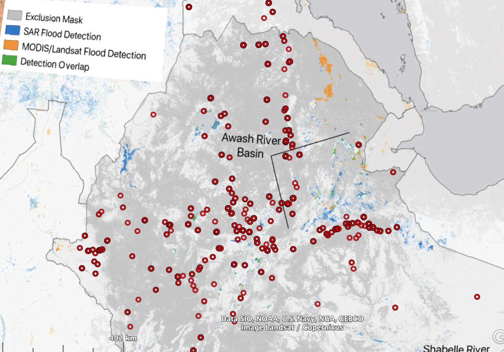
Unlike in the Pakistan example, there’s not much in the way of genebank accessions from areas of Ethiopia that are particularly at risk from flooding, it seems from this. However, Genesys does not (yet) include geographic provenance data for sorghum from the national genebank of Ethiopia. The 4000-odd sorghum accession from Ethiopia currently in Genesys are conserved at ICRISAT.