New Plant Hardiness Zone Map ready for prime time

There’s a USDA media blitz on about the new Plant Hardiness Zone Map for the United States.

The 2012 USDA Plant Hardiness Zone Map is the standard by which gardeners and growers can determine which plants are most likely to thrive at a location. The map is based on the average annual minimum winter temperature, divided into 10-degree F zones.

You can read the paper. You can read the press coverage. And you can watch the video.

The good news for America’s 80 million gardeners is that for the first time the map is available in an online interactive version, and is a lot more accurate. The bad news is that things are getting hotter, and many of those gardeners are going to have to rethink their choices:

The new PHZM is generally one half-zone warmer than the previous PHZM throughout much of the United States, as a result of a more recent averaging period (1974–1986 vs. 1976–2005).

But then we knew that. As far as I can see, you can’t compare the new version with the old online, side by side kind of thing. That would be one powerful climate change advocacy tool, wouldn’t it. Gardeners don’t like to be messed with, in my experience.
Kermit sings the malnutrition blues

When you start really looking out for something, you quickly get to wondering how you could possibly have missed it all before. Case in point: maps of the USA which hint at “a complex association where interactions between a variety of factors could produce reinforcing effects.” That’s in the words of an Annals of Botany Google+ pointer to a recent post of ours here which included maps of obesity and food insecurity and mused vaguely about the coolness of mashups.

After that, of course I started seeing such maps everywhere. Of renewable resources, including biomass. Of landuse. Of poverty. Of, errr, the names of soft drinks.

Some regions jump up at you during the even briefest of looks at the maps of poverty, obesity and food insecurity. Like the Mississippi Valley, for instance. So it is at least somewhat reassuring that other people have noticed that too, and are doing something about it. Even doing multiple things about it, in fact. USDA probably didn’t need fancy maps to identify this particular nexus of deprivation, but maybe there are others that are not so obvious, and which an in-depth perusal of these maps will bring to light. Along with, hopefully, some possible solutions. Even if they are only farmers markets.

But to end on a lighter note, this region is not just known for poverty and malnutrition. The blues came from there, of course, but also, ahem, Kermit the Frog. In fact, there’s a connection between our green friend and agriculture. I am reliably informed that Jim Henson’s father was superintendent of the USDA-ARS research station in Stoneville, MS and worked closely with researchers there. Perhaps Kermit should be asked to spread the nutrition and exercise message around his old hopping grounds? I can’t think of a more suitable role model.

Nibbles: Mike Jackson blog, Philippines genebank fire, Ancient garden, USA maps, Horse domestication, Gnats, Livestock training, Chocolate, Epigenetics, Indian nutritional security, Kew fund, GM bananas, Reconciling databases

Mapping America

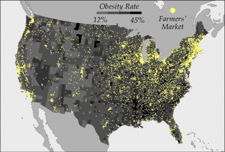
So there I was Scooping away, and what should turn up among the stuff I follow, and almost side by side on the screen to boot? Well, this map of obesity rates and farmer markets in the USA:

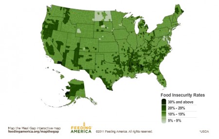
And, I kid you not, this map of food insecurity in, you guessed it, the USA.

Eyeballing does suggest a certain association between obesity and food insecurity, doesn’t it? Talk about the double burden of malnutrition. Oh the fun one could have mixing and matching such maps, and the no doubt dozens of others that also exist out there, documenting the geographic distribution of McDonald’s, organic farms, drunkenness, gyms, pet ownership, house prices, fizzy drink consumption, weed busts…

Crop wild relatives of the USA

I’ve just come across the Jepson Flora Project, which

brings together all of the floristic references and data of the Jepson Herbarium. Resources of the Flora Project are directly linked the the Consortium of California Herbaria, CalPhotos, the California Native Plant Society, California Exotic Pest Plant Council, USDA-Plants database, and many other external sites. The Friends of the Jepson Herbarium help the Jepson Flora project carry out its work.

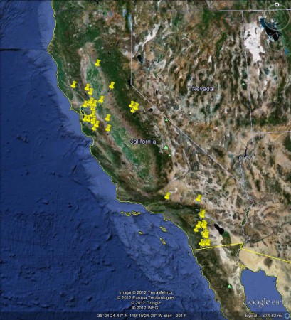
It doesn’t look particularly nice, but I do like the idea of aggregating all kinds of information about each taxon, like Helianthus californicus for instance, via the Jepson Online Interchange. From that admittedly ugly page you can dig deeper, and for example get a digest of taxonomic, distribution and phenology information based on specimens from members of the Consortium of California Herbaria. They don’t make it particularly easy for you 1 but you can, wonder of wonders, even export the location data to Google Earth, where you can mess with it as you wish.

I wonder how many other US states have something similar. And whether all their data on crop wild relatives could then automagically be aggregated up to the national level. Colin, are you there?