- To a hammer, everything is a nail; Decanter magazine bemoans loss of sake breweries in Japan.
- One door closes, another one opens; “price winning” Croatian wines.
- Why go to Kew when you can tour with Google streetview?
- Slideshow on genebanks and climate change adaptation in Ethiopia. Wish I could hear the words.
- Canadians! Your heritage crops and breeds need you.
- How best to dry banana slices in Ethiopia.
Nibbles: Intensification, Turnips, Colourful breeding, Development, CGIAR Research Programs, C4 ALV, IRRI,
- Ecological intensification: some new science to use.
- Tetraploid turnip tolerates salt.
- The Scientist Gardener does colourful pepper (mostly) breeding.
- “Envy holds back agricultural development.” Say wha?
- IFPRI sells what it is up to on Policies and Nutrition.
- Cleome gynandra is a C4 plant with wonderful adaptations; I bet the people eating it don’t know that.
- IRRI impresses UK diplomat, especially the genebank.
More messing about with Droppr
I continued my exploration of IFPRI’s wonderful Droppr software by looking at its future climate tool. You click on a spot on the Earth and it tells you how total precipitation and average temperature will change, for each month of the year. Again, I did it for the mother-in-law’s farm, and this is the result:


Looks pretty bad, at least for temperature. Although of course, for maize at least, which is the main food crop in that area, what you really want to know is peak, rather than average, temperatures. That’s according to a study by David Lobell and Marianne Bänziger we nibbled a few days back, and which recently got a big write up in The Economist:
Days above 30°C are particularly damaging. In otherwise normal conditions, every day the temperature is over this threshold diminishes yields by at least 1%. Moreover, days where the temperature exceeds 32°C do twice the harm of those at 31°C. And during a drought, things are worse still. Then, yields take a hit of 1.7% per day over 30°C.
Seeds and architecture, Greek style
Two events don’t constitute a trend; that takes three. But I note with interest that Greece’s entry in the 12th International Architecture Exhibition in Venice is Ark. Old seeds for new cultures. Readers will remember that the UK Pavilion at the Shanghai Expo of 2010 featured a Seed Cathedral.
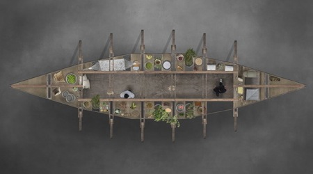
Greece’s effort is much more rooted in food than the UK’s. The Greek Ark Project helpfully explains:
The oldest meaning of the ancient greek word for the activity of building, ktisis, is “weeding, preparation of the soil for sowing, planting“, while the meanings of ‘foundation’ and ‘construction’ are subsequent. Sowing and Construction introduce at the outset a dual function for architecture as the activity of organizing both buildings in space and, also, of open, natural spaces. By means of the present project, we seek to reintroduce into contemporary architectural practices the spaces of culture in its double meaning, of agriculture and of civilization. “People meet within culture”.
It goes on to place the architecture squarely within the realm of agriculture.
And thanks to The History of Greek Food for the original post and the photograph.
Ground-truthing SPAM
Jeff Horwich has an interesting post over at HarvestChoice Labs looking at the effect of the tsunami on agriculture in northern Japan. He used the Droppr tool, which combines Google Maps with lots of other data, in this particular case the world-wide crop distribution data from the Spatial Production Allocation Model (SPAM). In SPAM
…tabular crop production statistics are blended judiciously with an array of other secondary data to assess the production of specific crops within individual ‘pixels’ – typically 25–100 square kilometers in size. The information utilized includes crop production statistics, farming system characteristics, satellite-derived land cover data, biophysical crop suitability assessments, and population density.
Intrigued, I decided to do a little lighthearted ground-truthing of the SPAM data. I only looked at one location, I admit, but what I found was a bit disappointing. I zoomed in on the location of the mother-in-law’s farm in the Limuru highlands (-1° 4′ 39.60″, +36° 40′ 44.80″). Here’s what the place looks like.

This is the view from space, courtesy of Google Earth. 1

Now, according to the SPAM methodology that’s a cropping intensity of 0.59%, with the main crops being sorghum, sweet potato/yam, groundnut, banana/plantain, potato, coffee and sugarcane.
Jeff very niftily embedded both a map and a spreadsheet of the production data for the main crops in his post, but I wasn’t able to work out how to do that. So you’ll have to make do with this wholly inadequate screengrab, I’m afraid.

What my mother-in-law and her neighbours actually grow is maize, beans, potato and tea, tea and tea. A pretty different set of agrobiodiversity to what SPAM thinks. And I think she would be surprised at the low value of cropping intensity. This is a very high-potential area.
Anyway, that’s only one data point. It would be interesting to know from the SPAM guys if there’s a more systematic attempt going on to check on, and refine, the results of the model.