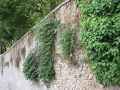
Capparis on this occasion. But I’ve also seen figs, pomegranate and assorted crop wild relatives growing on walls. Time for a serious survey?
Nibbles: Refugia, Mann, Tree pix, Sparing v sharing, Lethal yellowing, Value chains, Coral sun-blocking, GlobalHort, Gravenstein, Pirate agrobiodiversity
- How species survive climate change.
- Charles C. Mann, author of great books on pre-Columbian America and the consequences of the Columbian Exchange, interviewed.
- Dreamy pictures of old British trees.
- “Protecting wild species may require growing more food on less land.” Great press release headlines of our times. Fortunately Mongabay has a discussion.
- Coconut lethal yellowing wreaking havoc in Mozambique.
- What makes a good food value chain?
- Boffins want to re-activate coral genes in temperate plants to stop them getting sunstroke. Or something.
- Old friend engaged by GlobalHort to work on position paper on “Promoting Agrobiodiversity for International Development: A Rationale and Roadmap for Collective Action”. Go, Hannah.
- Grapes vs apples in Sonoma County.
- Aaargh, pirates smoked like chimneys and drank like fish. Well I never. Anyway, nice to see them making full use of the local agrobiodiversity products.
Chile Pepper Fiesta 2011


Chile Pepper Fiesta 2011, a set by Brooklyn Botanic Garden on Flickr.
Looks like fun…
Nibbles: Gardens, Heirloom tomatoes, Maple beetles, Nepali citrus, Guyana adaptation, Indian policy, GMOS, Apple festivals
- Nourishing the Planet featured in Madison paper. Fame at last.
- Tomato Party!
- What, no more maple syrup? Something Must Be Done!
- Nepal gets a citrus genebank.
- Guyanese women farmers switch to coconuts (and other things) to cope with flooding.
- Indian farmers demand another Green Revolution.
- Uh-oh. “GMO corn falls prey to bugs it was supposed to thwart“.
- First news of apple festivals, in Vancouver, CA.
Machu Picchu and maize up in lights
 The pretty stunning light show put on in the main square in Cuzco for the 100th anniversary of the re-discovery of Machu Picchu includes something to do with maize at around 5 minutes in. I’ve taken a screen grab (right), but it’s really worth seeing the whole thing. Maybe some expert can tell us what the maize bit represents. Thanks, Charlotte.
Machu Picchu 100 Años from PROJEKTIL on Vimeo.