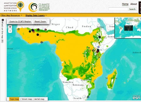
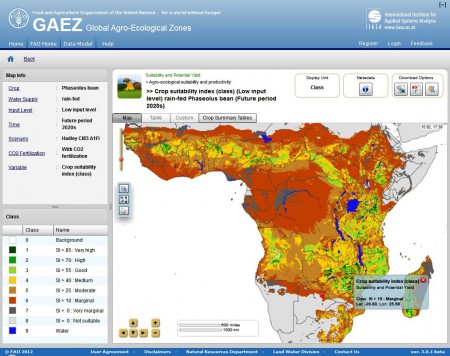
There seems — inevitably — to be something of a competition out there to produce maps of changes in climatic suitability for different crops. And I’m not saying that’s necessarily a bad thing. The recent launch of FAO’s GAEZ Data Portal gives us a much-needed alternative to the all-but-unusable offering by CCAFS. Sad to say, it is not much of an alternative.
Here’s the quick version. CCAFS’s Adaptation and Mitigation Knowledge Network allows you to map current suitability, future suitability and change in suitability for a few crops. The example below is change of suitability for Phaseolus beans in Africa. I wasn’t able to get rid of those extraneous place markers, nor to export the results other than by screengrab, nor to import my own data to super-impose, nor to include the legend in any sensible way.

FAO tries to fill the gaping hole left by this well-meaning but flawed tool by providing something that: has menus which are extremely cumbersome to navigate; does not include change in suitability, but then doesn’t let you combine present and future suitability to do your own analysis; does allow you to choose different climate models, but again not to combine the results; does allow various download options, none of them particularly useful, and then only if you register; and, needless to say, doesn’t allow you to import data.

It’s hard to say how one could better replicate, and in fact accentuate, the bad features of one tool, while ignoring whatever good things it had. Frankly, I’m running out of patience with websites which are clearly designed by one set of geeks for another set of geeks. Meanwhile, users — you know, the people for whom this stuff is allegedly produced — are left to cry over their keyboards, and think of what might have been. And regret the fact that they’ll never get back the hour they’ve just wasted.
About your patience running out, you can’t really blame the “geeks”. I think the culprits in these initiative (customised online-web map portals two-O and variants) are the bored, misdirected info-comm-know managers and officers wanting such a tool on their corporate website.
Adding to your comments: When building a publication-grade map, no online pseudo-GIS can help. The much needed metadata for layers and datasets is missing or incomplete. Spatial analysis is impossible. And what control over the legend and annotation placement do you have in the end? From the initial, conceptual data model to the datasets, to the analysis, to the actual map, none of these tools do a half-decent job. I wonder who is using them? Really using them, who?
‘GIS and cartography’ is time-consuming. It needs planning, drawings, models, trials and errors, tons of little tweaks….
From the many web mapping tools that exist, I still have to find one that is complete in terms of functionnality. The WRI’s DRC interactive Forest Atlas is polished and ergonomic though it is an atlas (no analysis). http://goo.gl/eTOXD
IMHO, confusion reigns about what online gis/cartography can bring to users. Planning should put the end-user at the center of the model. The two web map tools you discuss here have no clearly-defined users, only always a vague wonderspeech. Some want the data to play with on their own terms and tools, other just want a finished map with 2-3 layers for a specific region, and others still want layer analytical capacity and geo-data creation (new datasets).
For the geek, building the tools you discuss, is fairly straightforward: use simple SQL query logic, store a static DB of geo-datasets, extract and visualise. But the geek get his orders/ToR from the clients. If the latter has no idea what is needed, then the final project may look good and do stuff, but it will not be used.
A different approach should be adopted towards online geographic information. When reading any official, international reports by any respectable INGO, you realise none of the maps they contain are produced by these tools. GIS Pros did them, ad hoc.
Geographers and cartographers often use 2-3 three different software packages for data analysis: they will probably never settle around one tool, online at that, and create a ‘community’ of users there. Instead, the NGOs interested in such a tool should rather offer geo-info advice and look at light open-source gis software to distribute: how many development workers in the field have had difficulties with the (basic) tabular conversions associated with GPS data ? Many many me thinks.