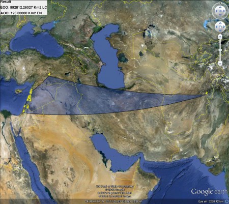
A random tweet from Stefano Padulosi at the big IUCN conference in Korea alerted me to the existence of something called GeoCAT. Funny how you can follow a topic assiduously and still miss important stuff and then come across it entirely by chance. Anyway, GeoCAT is an online tool developed by Kew and Vizzuality, with support from IUCN and others, that “performs rapid geospatial analysis for Red List assessment.” ((Bachman S, Moat J, Hill AW, de la Torre J, Scott B “Supporting Red List threat assessments with GeoCAT: geospatial conservation assessment tool.” (2011) In: Smith V, Penev L (Eds) e-Infrastructures for data publishing in biodiversity science. ZooKeys 150: 117–126. (Version BETA). ))
It all starts by providing some species occurrence data. You can import data from GBIF or, interestingly, Flickr. Or you can upload your own data. Or you can add or edit points on the map itself. All three options seem to work fine. Then you have to click on a little button labelled “Enables EOO/AOO.” It took me some time to figure that out. What that does is it uses the occurrence data to calculate two things: Extent of Occurrence (EOO) and Area of Occupancy (AOO). “These two measures are the foundation of the ‘B’ criterion of the IUCN Red List system.” I’ll let Wikipedia define them:
The EOO can best be thought of as the minimum convex polygon encompassing all known normal occurrences of a particular species, and is the measure of range most commonly found in field guides. The AOO is the subset of the EOO where the species actually occurs. In essence, the AOO acknowledges that there are holes in the distribution of a species within its EOO, and attempts to correct for these vacancies. A common way to describe the AOO of a species is to divide the study region into a matrix of cells and record if the species is present in or absent from each cell.
That done, you click on “Print complete report” and that opens another browser tab which has a map of the occurrences, the EOO and AOO figures, and a preliminary assessment of threat, according to the IUCN system. What it doesn’t have, is a reference to what species you’re dealing with, but the thing is still in Beta, they’ll work such things out in due course. You can also download the results for use in Google Earth, from whence I derived the following, for Cicer judaicum, as it happens.
No, I don’t know if that lone record off to the east is valid, but fear not, if you think it’s suspect, you can easily edit it out. Not bad. Not bad at all.

Hey Luigi,
It is true that the tool still needs a lot of work, but I just wanted to point out that you can name your assessment. To the upper left of the map, if you click the default untitled name you can add a name such as,
Gymnogyps californianus
Which would help you keep your reports sorted later.
Cheers,
Andrew
Thanks, sorry I missed that.