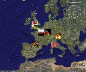
Here’s a fun thing. There’s a group pool on Flickr, the photo sharing site, called “tomatoes!” 1 All kinds of pictures of all kinds of tomatoes, and very beautiful is all that diversity to look at too. But you can do more. Like for example map where the photos were taken (assuming the photographer uploaded a georeference). Which could give you a snapshot of where tomatoes are grown or consumed — or maybe just particularly loved. You can also generate a kml file. Here’s what you get when you view it in Google Earth:

Haven’t quite worked it out. This doesn’t seem to be all the georeferenced tomato photos from Europe in the group. Maybe just the latest to be uploaded. But I can’t help thinking this is a great way of displaying the geographic distribution of agricultural biodiversity.
- And also similar pools for lots of other plants.
Could this help identifying market needs and tomato cropping likelihood in the different regions? (I guess the uploaders would need to say when the photograph is from a nearby farm or is imported from another region).