So it’s true. Given enough baboons, and enough time, you can do anything. Even germplasm evaluation.
The Genomics of Genebanks Workshop at PAG deconstructed
Greg Baute has a post up at his blog on the Genomics of Genebanks Workshop held last week at the Plant and Animal Genome Conference. Interesting observations on core collections, comparing past genebank collections to current diversity in the field, and the role of crop wild relatives in breeding. I particularly liked Cameron Peace’s advice on how to get the most from collections of wild relatives of fruit trees. Maybe we’ll hear more about that at Davis in March.
Nibbles: Mongolian asses
- It’s always good to be able nibble a paper with “wild asses” in the title. Especially since there’s nothing else on the internet today.
A plate of exotic agrobiodiversity
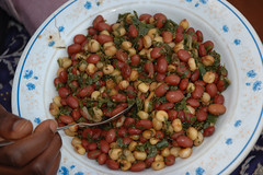
It’s a nice illustration of our interdependence for agricultural biodiversity that an East African staple dish can be made up of New World crops. Now, if only that green stuff in there were one of those interesting traditional African vegetables rather than the more likely sukuma wiki (kale), that would really make a great story.
Of cattle and people. And barley
Dienekes, a blogger who specializes in molecular anthropology, has a quick note today on a paper on the molecular genetics of cattle in Europe. The main story is one of distinction between North and South.

Apparently, the expansion of the dairy breeds have created, or largely maintained, a sharp genetic contrast of northern and southern Europe, which divides both France and Germany. It may be hypothesised that the northern landscapes, with large flat meadows, are suitable for large-scale farming with specialised dairy cattle (Niederungsvieh, lowland cattle), whilst the mixed-purpose or beef cattle (Höhenvieh, highland cattle) are better suited to the smaller farms and hilly regions of the south. However, it is also remarkable that in both France and Germany the bovine genetic boundary coincides with historic linguistic and cultural boundaries. In France, the Frankish invasion in the north created the difference between the northern langue d’oïl and the southern langue d’oc. The German language is still divided into the southern Hochdeutsch and northern Niederdeutsch dialects, which also correlates with the distribution of the Catholic and Protestant religions. On a larger scale, it is tempting to speculate that the difference between two types of European cattle reflects, and has even reinforced, the traditional and still visible contrast of Roman and Germanic Europe.
It doesn’t seem that the strong latitudinal genetic differentiation in cattle is matched by one in human populations. Here the pattern is much more gradual and clinal. 1 However, there may be a similar “sharp genetic contrast of northern and southern Europe” (or at least between the Mediterranean and the rest of Europe) for barley. 2

I’d dearly love to have the time to find out whether other livestock and crops show a similar pattern.