- Developer of super broccoli reflects on his career. With photo of collectors in NSFW shorts.
- Touring the commons of the world. Thankfully no tight shorts in sight.
- Video explaining Rothamsted’s Park Grass experiment. Apparel entirely acceptable, don’t worry.
- Ten million-year-old genome duplication finally came good when ancient farmers domesticated maize.
- Training materials for African breeders to be developed.
- Fungal diversity to the rescue of plants, for a change.
- Africa’s black soap.
- Improving teff. That’s a low bar, I suspect.
- A genome I’m sure we can all get behind.
- Oh dear, that organic meta-analysis “flawed” after all. Will it ever end?
- Rethinking sunflower domestication. An oldie but goldie, which re-surfaced today for some reason. Does anyone know where we are with this now?
- The Deliverance of tomatoes.
Botany on the Beeb
I’m sure we’re all excited about the new BBC series, “Plants: From Roots to Riches,” which begins on Radio 4 on Monday, 21 July. You can even subscribe to a podcast, so there’s really no excuse for missing any of it. We’ll try to provide regular recaps, replete with spoilers.
Bananas galore
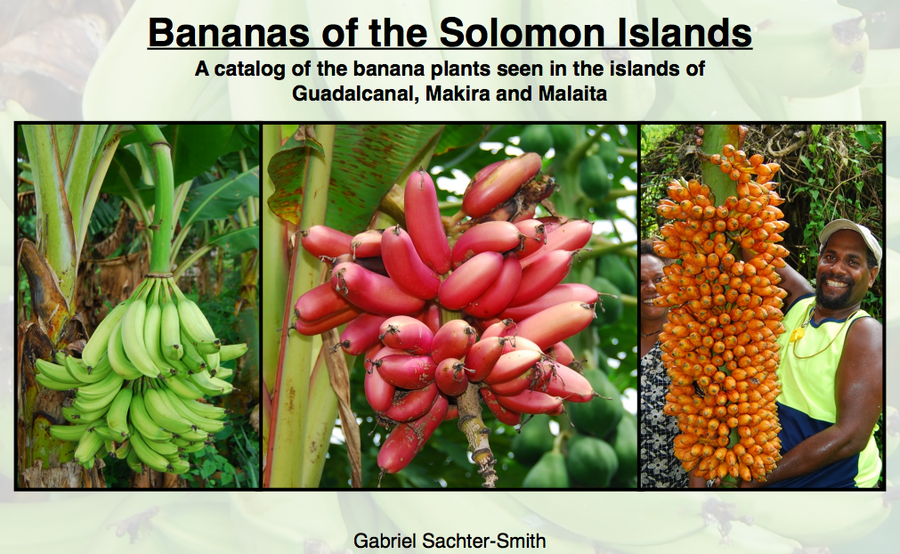
Rosa would certainly have welcomed a great new 1 catalogue of some 50 banana varieties from the Solomon Islands by Gabriel Sachter-Smith, put out by ProMusa. The varieties on the cover are Broken Heart, Ruhuvia Chichi and Ba’u Lalao.
Oh, and there’s also a new wild subspecies from India.
Nibbles: Coffee processing, British liquorice, Livestock maps, Chicken semen, Global Nutrition Report, Plant booze, Cuban urban ag, Forests & nutrition, Sustainable cacao, Climate-smart ag, Modelling landuse, Mapuche up in arms, Rothamstead experiment
- Touring the world’s coffee processors.
- Liquorice next? Starting in the UK?
- India has 30% of the world’s cattle. Which you might not be able to guess from these very cool ILRI maps. Including one on chickens, in which the Nordic countries feature perhaps less than they should.
- The Global Nutrition Report will have these indicators at country level. Some stuff there on fruit and vegetable consumption, but why nothing specifically on dietary diversity? Anyway, if you’d like to make suggestions, you can.
- Wait, why is there nothing on alcohol consumption? And is diversity in alcohol-producing plants a good thing? I mean, nutrition-wise.
- Uhm, nothing on urban agriculture either. I bet you that’s an indicator of something or other, nutrition-wise.
- Maybe Amy Ickowitz of CIFOR will suggest some indicators. She has interesting data on forest cover and child nutrition.
- How to make cacao cultivation more sustainable.
- Andy Jarvis on how to scale up climate-smart agriculture without necessarily sacrificing goats. Nor, presumably, nutrition.
- Model says environment can support subsistence hunting and agriculture only up to a point, and no more. Still no cure for cancer. But did someone tell the Mapuche?
- Well, what do you know, genes come, and genes go.
Nibbles: Millet festival, Seed eBay, Fonio frenzy, Kenya mangoes, Barbed wire, Potato diversity, Peruvian cuisine, Feeding Haiti, Shea paradox, Prosopis review, Nigerian genebank, COGENT meeting, IRRI genebank, Big Data on diseases, Genomics at UBham
- There’s a millet festival in Chennai on 20 July. Any of our readers planning to go?
- “…the first ever, non-profit “eBay” of seed…” And you can contribute, if you like. With money, that is. I wonder if there will be a festival at some point.
- Fonio gets the Mail treatment (but no festival). Will it ever recover? Maybe this will help. For the record, it may have been the The Guardian that started this fonio frenzy. Anyway, here are the collections, if you think you’d like to contribute to the revolution. Like by organizing a festival. But why stop at fonio…
- Sometimes, however, exotic is better: like mango in Kenya. There’s plenty of mango festivals (and a new genebank too) in India, but not in Kenya, as far as I know.
- BBC radio programme on the history of barbed wire. Fascinating.
- Not to be outdone, DW on potato agrobiodiversity, including the CIP genebank. Wow, in Spanish too. Ah, but do any of them have high levels of B-9 vitamin? No? I know someone who can change that.
- More to Peruvian cuisine than potatoes, though. I feel a festival coming on.
- Food aid vs agriculture in Haiti. Nothing to celebrate there.
- Someone mention hard choices? Shea harvesting in Ghana presents a conundrum too.
- What can I tell you about Prosopis? Some are good, others not so much.
- I guess the same could be said for Solanums.
- Around the world in 20 food photos. No festivals? Well, I think Ramadan qualifies.
- “I have told you that NACGRAB would have been in a mess without the support of WAAPP.” Head of Nigerian genebank tells the world like it is.
- Coconut genebank managers tell each other like it is.
- Rice genebank makes an impression, visitor tells the world.
- I suppose we should have at least one Big Data thing, right? Make that two. But that’s all you get.
- Ok, then, one last one: diseases, genomics and, of course, football.