The collaborative project “Predicting climate change-induced vulnerability of African agricultural systems to major insect pests through advanced insect phenology modeling and decision aid development for adaptation planning” was led by CIP and implemented in collaboration with the International Centre of Insect Physiology and Ecology (icipe) and the International Institute for Tropical Agriculture (IITA). In the project, pest risk assessments under potential future climates were conducted for a number of important insect pests of agricultural and horticultural crops in Africa (i.e., potato, sweetpotato, vegetables, maize, cassava, and fruit). Results of these assessments are presented in the Pest Distribution and Risk Atlas for Africa (Pest Risk Atlas for Africa, for short).
And here it is, covering 3 potato pests, 5 for sweetpotato, 4 for vegetables and 5 for maize. For each pest, there’s a lot of information on detection and identification, biology, impact, and control, as well as a detailed geographic analysis of distribution and severity, now and in the future, at various scales.
Check out, for example, what’s going to happen to sweetpotato whitefly (Bemisia tabaci) in Africa (there are also global and country maps, in this case).
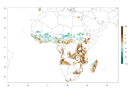
This shows the absolute change in potential population growth between 2000 and 2050. Note the bad news for Central Kenya, which will be interest the mother-in-law, who rents out some bottomland for sweetpotato. And she’ll have plenty of Chinese company, by the looks of the global maps.
At least, I guess so. It’s difficult to be sure when all you have are maps in the form of images. I do hope they’ll be available on Google Earth in due course, for researchers (and indeed farmers) who want to drill down a bit.