It seems we missed, back in August, a huge report on CGIAR’s work on ecosystem restoration. After a thorough stocktaking, the report suggests the following are critical for successful restoration:
- secure tenure and use rights
- access to markets (for inputs and outputs) and services
- access to information, knowledge and know-how associated with sustainable and locally adapted land use and land management practices
- awareness of the status of local ecosystem services, often used as a baseline to assess the level of degradation
- high potential for restoration to contribute to global ecosystem services and attract international donors
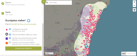
Which seems sensible. At least if “practices” in 3 and “services” in 4 and 5 include some consideration of genetic diversity. And on that note, it’s also about time we linked to the Royal Botanic Gardens Sydney’s page on Restore & Renew (R&R).
It only covers New South Wales and Victoria, but the R&R Webtool could be something for CGIAR to run with globally. You pick a spot you want to restore, and, for a selection of trees, it tells you where best to source germplasm from. That’s based on current climate, future climate and, crucially, genetic similarity 1 (if data are available).
Of course, this is just the start. Scaling up the supply of tree seeds for landscape restoration remains a major challenge. A recent review, also involving CGIAR scientists, makes quite a few useful recommendations. But in the end, I suspect, it will come down to this:
- put in place incentives and enabling policies to support smallholders in producing, trading and using high-quality genetically diverse reproductive materials