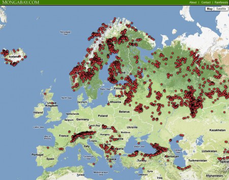
The redoubtable Mongabay.com has just announced the beta version of the Global Forest Disturbance Alert System (GloF-DAS). How it works is that four times a year (at the end of March, June, September and December) the CASA ecosystem modeling team at the NASA Ames Research Center produce something called the “Quarterly Indicator of Cover Change” (QUICC). This compares global vegetation index images from NASA’s Moderate Resolution Imaging Spectroradiometer (MODIS) from exactly a year before with the ones they just got. GloF-DAS then takes the QUICC data and maps the location of forest disturbance as the center points of 5×5 km areas where there was a >40% loss of forest greenness cover over the previous 12 months.
Here’s the result for Europe, for the year period ending March 2012.
There’s some issue I’d take with this approach. Most importantly, comparing March with March is not necessarily comparing vegetation at the same level of seasonal development in the temperate zone. But I think this is a great step forward in developing a global system for monitoring threats of genetic erosion. As the developers point out:
The cause(s) of any forest disturbance point detected in this map has yet to be confirmed.
Disturbance locations and impacts are subject to verification through local observations.
So imagine a next iteration of the system where local observers can annotate some of those potential disturbance points. A bit like what happens in the National Phenology Network in the USA, though for a different purpose. ((And there are other relevant citizen science efforts, of course, whose importance is being increasingly recognized. LATER: Gosh, I just found another…)) And information will flow out more freely too.
In coming months, GloF-DAS will offer an alert system whereby users can sign up to get notifications via email or SMS text message on recent changes in forest cover for a specified location or country.
Of course, for this to be truly a game-changer we who are interested in monitoring threats to crop wild relatives, say, would need the ability to combine the potential threat data of GloF-DAS with our own data on species occurrence or diversity. It doesn’t look to me like that’s possible just now, but perhaps it is something that we as a community can suggest to the developers.

For the GIS challenged (like myself) Google Spreadsheet Mapper seems to have possibilities.
I have difficulty imagining the processing power needed to produce a worldwide QUICC every three month. Nasa’s firepower sure helps here, I believe.
The notification system based on this automated process (QUICC production and marker generation) is an idea well worth researching. For a simple and solid alert/update system (disturbance at X, go to X, identify and classify disturbance, update marker information), this initiative seems to make good sense.
It would be interesting to know what remote sensing product(s) would serve best the monitoring of threats to CWRs, though. In this particular case, is a 40% year-to-year variation in vegetation index (ie, the reduction in green vegetation cover) enough information to justify dispatching field observers?
Imho, a more sophisticated alert system would ask for the discretisation of the 5x5km squares, to permit the storing and timestamping of data related to each of them. That would add much to the processing time. And maybe, instead of an all-in-one solution, it would be best to have the global alert system (already data heavy) only loosely linked (no hard integration) to the threat database.