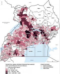
Want to know where Ugandans can make the most money from harvesting papyrus? Here you go:

This map is one of a whole series on Ugandan wetlands — their potential and the threats they face — that has just been published by the World Resources Institute ((In collaboration with Uganda’s Wetlands Management Department, the Uganda Bureau of Statistics, and the International Livestock Research Institute.)) under the title Mapping a Better Future: How Spatial Analysis Can Benefit Wetlands and Reduce Poverty in Uganda.
One of the co-authors, Paul Mafabi , commissioner of the Wetlands Management Department in Uganda’s Ministry of Water and Environment, had this to say at the launch:
These maps and analysis enable us to identify and place an economic value on the nation’s wetlands. They show where wetland management can have the greatest impacts on reducing poverty.
There are probably some wild rice relatives lurking in these wetlands too, let’s not forget.