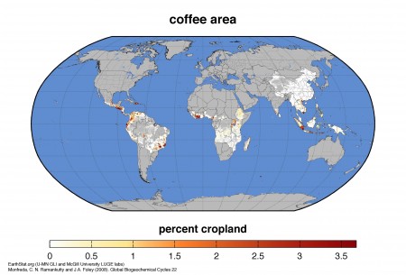
Those of you last summer who followed a link in a post of ours on crop distribution mapping to
…the dataset of Monfreda et al. (2008), “Farming the planet: 2. Geographic distribution of crop areas, yields, physiological types, and net primary production in the year 2000″…
will have ended up on a file directory containing a whole bunch of crop-specific zip files, from which you could have eventually extracted the modeled distribution of, say, coffee:
Or whatever. Nice, but all a bit fiddly. Well, now there’s a much nicer way of downloading the data in all kinds of useful forms, including Google Earth files. Though you do have to register.
I wonder if ICARDA used these data, or some others, to do their recent work on the impact of climate change on wheat in Central Asia. Difficult to tell from the blurb.