A blog post from the Chicago Council on Global Affairs a couple of days ago reminded me that we had blogged about GYGA — the Global Yield Gap and Water Productivity Atlas — a couple of years back. Just to remind us all
…the target of the Global Yield Gap Atlas (GYGA) is to provide best available estimates of the exploitable yield gap (Yg-E) — difference between current average farm yields and 80% of Yp and Yw. Water resources to support rainfed and irrigated agriculture also are limited, which means efficiency in converting water to food, water productivity (WP), is another key food security benchmark included in the Atlas.
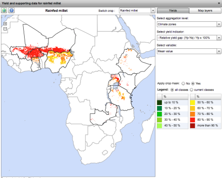
I’ve had a quick look at the GYGA website, and it seems serviceable enough, though it has the drawbacks, often remarked on in these pages, that it is difficult to share the maps you make, and import your own data into them. Here I’d like to point out another potential issue, though. This is what you get when you look at the yield gap for “rainfed millet.” Because of the aforementioned drawbacks, a clunky screenshot is the best I can manage, I’m afraid.
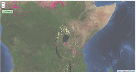
Now, the stuff in West Africa is clearly pearl millet, but what about in East Africa? Is there really that much pearl millet in Uganda, say? This is what Genesys knows about the two millets in East Africa. And yes, it’s a clunky screen grab too, but if I had wanted to, I could have downloaded separate KML files for the two crops and opened them both in Google Earth and then exported a nice JPG.
Pink is pearl, yellow is finger. There’s a little bit of pearl millet in Uganda, but not all that much. The millet there is mainly finger millet. So, which is the millet in GYGA? Is it confusing the two?


Luigi: There is a horrible gap in Kenya. I spent about 18 months around 1980 collecting sorghum and millets in Kenya attached to the FAO Katumani dryland farming project and I got far more than shown on the map – yellow or pink: there was lots of finger millet in Kenya used for traditional brewing. BUT this was the time of what became the NGO `biopiracy’ campaign. The Kenya Ministry of Environment (not Agriculture) refused to let my collection out of the country: one duplicate rotted for many years in a colleague’s garage and the other duplicate went to Kitale and probably died when the store coolers broke down. Kitale also had the Serere sorghum and millets – if the were lost that is a disaster (they were rescued by Kenyan staff when Serere closed)
Thanks. We hope that the Kenya genebank will share its data on Genesys in the near future. But would you agree that the millet in Uganda is more likely to be finger than pearl, unlike in West Africa?
Yes – probably finger millet needs more rain than pearl. There is also foxtail and panicum millet around in Kenya.
Looking for an answer to your question Luigi, I searched hastily through AJAR, a journal you don’t refer to a lot on this blog, for reason I can only guess.
But please have a look at this article ‘Major pearl millet diseases and their effects on-farm grain yield in Uganda‘ and this item ‘Uganda scientists developing disease-resistant pearl millet‘.
However, CGIAR on millet says Uganda is a major producer of finger millet. ICRISAT says ESA produces some pearl millet, while FAOStats shows Uganda producing ‘Millet’ (ie the commodity) 500k t/year on average from 1993 to 2007, dropping to half that amount (250k t/y) from 2008 onwards.
Probably looking in all the wrong places, or not in the right ones, and it’s Friday evening, but I would very like to get an answer: how do you find out an answer to such a question?
More here and here (Uganda is a ‘major producer’). Now, about finding the experts who where in the field: maybe former IntSorMil or current NARO, etc scientists?
Thanks! Seems to me you should start your own blog :)
Have you seen this?
Sorry to join in this late. Uganda certainly produces far more finger millet than pearl millet. The second map therefore gives a picture close to what is on ground.
Thanks, John.
Hi Luigi et al.,
Thanks for starting this discussion! In GYGA we use HarvestChoice’s SPAM crop distribution masks for our analysis. SPAM in turn uses FAO statistics to create spatially disaggregated maps of crop distribution. I looked in more detail to the FAOstat numbers and found out that their numbers for ‘millet’ are actually for all sorts of millets combined.
So finger and pearl millet are combined, even with teff to my big surprise! Identity crisis? ;-) In GYGA we have used a generic model for both pearl and finger millet so they are combined in the analysis…. Hope this helps. Thanks again for starting the discussion! Cheers, Lieven
Hi Lieven et al.,
Just a quick comment regarding teff and where FAO accounts for this commodity. In putting together data for SPAM I did more research into this and found that: although FAOSTAT says in its documentation that teff is part of millet (# 79), if you look at the numbers, the area and production of teff has been included in ‘Cereals, nes’ (# 108). This is also consistent with Ethiopia’s statistics.
Maybe FAO has to wake up to this as well!